Sharkfin Shoal Light
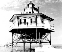 Undated photograph of Sharkfin Shoal Light (USCG) | |
  | |
| Location | Southwest of Clay Island at the mouth of the Nanticoke River |
|---|---|
| Coordinates | 38°12′07″N 75°59′12″W / 38.2020°N 75.9868°WCoordinates: 38°12′07″N 75°59′12″W / 38.2020°N 75.9868°W |
| Year first lit | 1892 |
| Deactivated | 1964 |
| Foundation | screw-pile |
| Construction | cast-iron/wood |
| Tower shape | hexagonal house |
| Height | 44 feet (13 m) |
| Original lens | fourth-order Fresnel lens |
| Characteristic | white 6 sec flash with red sector |
The Sharkfin Shoal Light was a screw-pile lighthouse located at the mouth of the Nanticoke River in the Chesapeake Bay.
History
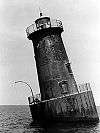
This light was constructed in 1892 to replace the Clay Island Light to the northeast. In 1964 the house was dismantled and a skeleton tower light placed on the foundation.
References
- "Historic Light Station Information and Photography: Maryland". United States Coast Guard Historian's Office.
- Sharkfin Shoal Light, from the Chesapeake Chapter of the United States Lighthouse Society
- de Gast, Robert (1973). The Lighthouses of the Chesapeake. Johns Hopkins University Press. p. 165.
External links
- Rowlett, Russ. "Lighthouses of the United States: Maryland". The Lighthouse Directory. University of North Carolina at Chapel Hill.
This article is issued from Wikipedia - version of the 10/15/2016. The text is available under the Creative Commons Attribution/Share Alike but additional terms may apply for the media files.