Leading Point Light
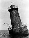
 Undated photograph of Leading Point Light (USCG) | |
  | |
| Location | Leading Point west of the Francis Scott Key Bridge on the south bank of the Patapsco River |
|---|---|
| Coordinates | 39°12′49″N 76°33′06″W / 39.2137°N 76.5518°WCoordinates: 39°12′49″N 76°33′06″W / 39.2137°N 76.5518°W |
| Year first lit | 1868 |
| Deactivated | 1924 |
| Construction | brick |
| Tower shape | house with lantern/daymark on roof |
| Height | 34 ft |
The Leading Point Light was an unusual lighthouse which displayed the rear light to the Brewerton Channel Range. It was eventually superseded by an iron tower on the same foundation.
History
This light was built in 1868, along with the Hawkins Point Light, to provide range lights marking the Brewerton Channel, excavated in the 1850s to provide a fixed deepwater channel into Baltimore Harbor. In form, it was like no other lighthouse in the area, a brick house with a short tower holding the lantern surmounted with a tall pole supporting a large ball, to be used as a daymark.
In 1924 both lights in this range were torn down and replaced with skeleton towers, which remain in use.
References
- "Historic Light Station Information and Photography: Maryland". United States Coast Guard Historian's Office.
- Brewerton Range Front Light, from the Chesapeake Chapter of the United States Lighthouse Society
External links
- Rowlett, Russ. "Lighthouses of the United States: Maryland". The Lighthouse Directory. University of North Carolina at Chapel Hill.
This article is issued from Wikipedia - version of the 10/15/2016. The text is available under the Creative Commons Attribution/Share Alike but additional terms may apply for the media files.