Sevier, Utah
| Sevier | |
|---|---|
| Unincorporated community | |
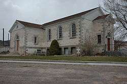
|
The old Sevier Ward Church | |
 Sevier Location within the state of Utah | |
| Coordinates: 38°35′11″N 112°15′30″W / 38.58639°N 112.25833°WCoordinates: 38°35′11″N 112°15′30″W / 38.58639°N 112.25833°W | |
| Country | United States |
| State | Utah |
| County | Sevier |
| Elevation | 5,584 ft (1,702 m) |
| Time zone | Mountain (MST) (UTC-7) |
| • Summer (DST) | MDT (UTC-6) |
| ZIP codes | 84766 |
| Area code(s) | 435 |
| GNIS feature ID | 1445446[1] |
Sevier /sɛˈvɪər/ is an unincorporated community in southwestern Sevier County, Utah, United States. It lies in the valley of the Sevier River along U.S. Route 89 southwest of the city of Richfield, the county seat of Sevier County.[2] Its elevation is 5,584 feet (1,702 m).[1] Although Sevier is unincorporated, it has a post office, with the ZIP code of 84766. It has a population of about 80 people. Sevier has many farms.[3]
Sevier has experienced rapid population growth in the 1990s and 2000s, and seasonal migrant laborers, mostly of Mexican and other Hispanic nationalities, made the population transfluid over the course of the year.
Climate
This climatic region is typified by large seasonal temperature differences, with warm to hot (and often humid) summers and cold (sometimes severely cold) winters. According to the Köppen Climate Classification system, Sevier has a humid continental climate, abbreviated "Dfb" on climate maps.[4]
References
- 1 2 "Sevier, Utah". Geographic Names Information System. United States Geological Survey. Retrieved 2008-04-12.
- ↑ Rand McNally. The Road Atlas '08. Chicago: Rand McNally, 2008, p. 102.
- ↑ Zip Code Lookup
- ↑ Climate Summary for Sevier, Utah
Municipalities and communities of Sevier County, Utah, United States | ||
|---|---|---|
| Cities | 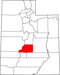 | |
| Towns | ||
| Unincorporated communities | ||
| Ghost town | ||