Serra da Bodoquena National Park
| Serra da Bodoquena National Park | |
|---|---|
| Parque Nacional da Serra da Bodoquena | |
|
IUCN category II (national park) | |
|
Serra da Bodoquena | |
 | |
| Nearest city | Bonito, Mato Grosso do Sul |
| Coordinates | 21°14′24″S 56°41′49″W / 21.24°S 56.697°WCoordinates: 21°14′24″S 56°41′49″W / 21.24°S 56.697°W |
| Area | 77,022 hectares (190,330 acres) |
| Designation | National park |
| Created | 21 September 2000 |
| Administrator | ICMBio |
Serra da Bodoquena National Park (Portuguese: Parque Nacional da Serra da Bodoquena) is a national park in the state of Mato Grosso do Sul, Brazil.
Location
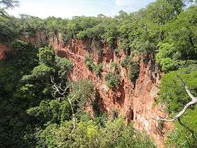
The park belongs to the cerrado biome. It covers an area of 77,022 hectares (190,330 acres), was created on 21 September 2000 and is administered by the Chico Mendes Institute for Biodiversity Conservation.[1] It covers parts of the municipalities of Porto Murtinho, Jardim, Bonito and Bodoquena, Mato Grosso do Sul.
Conservation
The park is classified as IUCN protected area category II (national park). It has the objectives of preserving natural ecosystems of great ecological relevance and scenic beauty, enabling scientific research, environmental education, outdoors recreation and eco-tourism.[2] Protected species include the catfish Ancistrus formoso, Jaguar (Panthera onca) and cougar (Puma concolor).[1]
Notes
| Wikimedia Commons has media related to Parque Nacional da Serra da Bodoquena. |
Sources
- Parque Nacional da Serra da Bodoquena (in Portuguese), Chico Mendes Institute for Biodiversity Conservation, retrieved 2016-05-02
- Unidade de Conservação: Parque Nacional da Serra da Bodoquena (in Portuguese), MMA: Ministério do Meio Ambiente, retrieved 2016-05-02