Bornheim (Rheinland)
For other uses, see Bornheim (disambiguation).
| Bornheim | ||
|---|---|---|
|
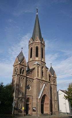
Church in Bornheim | ||
| ||
 Bornheim | ||
Location of Bornheim within Rhein-Sieg-Kreis district 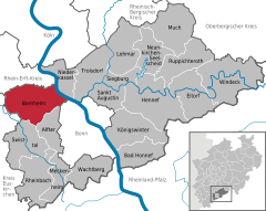
 | ||
| Coordinates: 50°45′33″N 7°0′18″E / 50.75917°N 7.00500°ECoordinates: 50°45′33″N 7°0′18″E / 50.75917°N 7.00500°E | ||
| Country | Germany | |
| State | North Rhine-Westphalia | |
| Admin. region | Köln | |
| District | Rhein-Sieg-Kreis | |
| Government | ||
| • Mayor | Wolfgang Henseler (SPD) | |
| Area | ||
| • Total | 82.72 km2 (31.94 sq mi) | |
| Population (2015-12-31)[1] | ||
| • Total | 47,636 | |
| • Density | 580/km2 (1,500/sq mi) | |
| Time zone | CET/CEST (UTC+1/+2) | |
| Postal codes | 53332 | |
| Dialling codes | 02222, 02227, 02236 (Widdig) | |
| Vehicle registration | SU | |
| Website | www.bornheim.de | |

Bornheim (Colognian: Bonnem) is a town in the Rhein-Sieg district, in North Rhine-Westphalia, Germany. It is situated on the West bank of the Rhine, approx. 10 km north-west of Bonn, 20 km south of Cologne.
The town borders on Bonn to the south, the towns of Alfter and Swisttal to the southwest, the town of Weilerswist to the west, the towns of Brühl and Wesseling to the north, as well as the Rhine-bordering town of Niederkassel in the east.
Bornheim is divided up into 14 districts: Bornheim, Brenig, Dersdorf, Hemmerich, Hersel, Kardorf, Merten, Rösberg, Roisdorf, Sechtem, Uedorf, Walberberg, Waldorf and Widdig.
Bornheim has a strong agricultural industry and is famous for its white asparagus.
Towns and municipalities in Rhein-Sieg-Kreis | ||
|---|---|---|
References
- ↑ "Amtliche Bevölkerungszahlen". Landesbetrieb Information und Technik NRW (in German). 18 July 2016.
This article is issued from Wikipedia - version of the 9/26/2016. The text is available under the Creative Commons Attribution/Share Alike but additional terms may apply for the media files.