Cologne (region)
| Cologne Regierungsbezirk Köln | |
|---|---|
| Regierungsbezirk | |
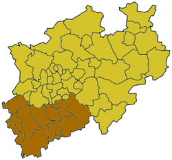 Map of North Rhine-Westphalia highlighting the Regierungsbezirk of Cologne | |
| Country | Germany |
| State | North Rhine-Westphalia |
| Region seat | Cologne |
| Area | |
| • Total | 7,364.71 km2 (2,843.53 sq mi) |
| Population (31 December 2015)[1] | |
| • Total | 4,422,371 |
| • Density | 600/km2 (1,600/sq mi) |
| Website | bezreg-koeln.nrw.de |
Cologne is one of the five governmental districts of the German Federal State of North Rhine-Westphalia. It is located in the south-west of that state and covers the hills of the Eifel as well as the Bergisches Land.
It was created in 1815, when Prussia reorganised its internal administration. In 1972 the Regierungsbezirk Aachen was incorporated.
| Kreise (districts) |
Kreisfreie Städte (district-free towns) |
|---|---|
External links
References
- ↑ "Amtliche Bevölkerungszahlen". Landesbetrieb Information und Technik NRW (in German). 18 July 2016.
Administrative regions (Regierungsbezirk) in North Rhine-Westphalia | |||
|---|---|---|---|
Coordinates: 50°50′N 6°55′E / 50.83°N 6.92°E
This article is issued from Wikipedia - version of the 8/20/2016. The text is available under the Creative Commons Attribution/Share Alike but additional terms may apply for the media files.