Schafberg Railway
| Schafbergbahn | |
|---|---|
|
Schafbergbahn near St. Wolfgang | |
| Overview | |
| Type | Rack railway |
| Locale |
|
| Termini |
St. Wolfgang Schafbergspitze |
| Stations | 4[1] |
| Operation | |
| Opened | 1893[1] |
| Owner | Austrian Federal Railways (ÖBB) |
| Operator(s) | SLB[1] |
| Technical | |
| Line length | 5.85 km (3.64 mi)[1] |
| Number of tracks | Single track[1] |
| Track gauge | 1,000 mm (3 ft 3 3⁄8 in)[1] |
| Electrification | no[1] |
| Maximum incline | 26%[1] |
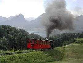
The Schafberg Railway (German: Schafbergbahn) is a metre gauge cog railway in Upper Austria and Salzburg leading from Sankt Wolfgang im Salzkammergut up to the Schafberg (1,783 m). With a total length of 5.85 km it gains about 1,200 m in height difference. Railway operation started in 1893.
Overview
The rail gauge is 1,000 mm (3 ft 3 3⁄8 in). It uses the Abt system. Today steam locomotives (both oil and coal fired), two modern Stadler-manufactured diesel locomotives,[2] and a diesel railcar are in operation. Owned by Austrian Federal Railways (ÖBB), it is operated by the local company SLB (SchafbergBahn und Wolfgangsee Schifffahrt), part of the Salzburg AG group,[1] that operates also the shipping on the Wolfgangsee lake.[3]
Route
The lower station is located in the east of St. Wolfgang (in the state of Upper Austria), in front of Wolfgangsee. After leaving the town, and starting to climb the mountain, the line enters in the municipal territory of St. Gilgen, in the state of Salzburg. Nearest railway was the Salzkammergut-Lokalbahn Salzburg-Bad Ischl (closed in 1957), that counted a "St. Wolfgang" station in the opposite side of the lake, linked to Schafbergbahn's one with a ferry.[4]
| Station[5][6] | Km | Amsl | Notes |
|---|---|---|---|
| St. Wolfgang | 0.00 |
542 |
lower station, train depot |
| Dorneralpe | 2.70 |
1,010 |
water station, no passenger service |
| Schafbergalpe | 4.00 |
1,363 |
guest house |
| Schafbergspitze | 5.85 |
1,732 |
summit station, guest house |
Gallery
 Going up Schafberg in a diesel railcar
 Schafberg Railway summit station
 Schafberg Railway train outside the summit station
 Schafberg Railway trains passing on the way down
 Locomotive Z13 at the summit station
 Diesel unit Z21 at St. Wolfgang
 Z12 at Schafbergalpe station
 Schafberg Railway 2008 video
Literature

- Gunter Mackinger: Schafbergbahn und Wolfgangseeschiffe. Verlag Kenning, Nordhorn, 2008 - ISBN 978-3-933613-92-9
See also
References
- 1 2 3 4 5 6 7 8 9 Infos about Schafbergbahn (official website)
- ↑ Railway Gazette, 03 Apr 2016 - SchafbergBahn rack locomotive delivered
- ↑ SLB: infos about the shipping (official website)
- ↑ SKGLB map of 1957 showing also the Schafberg Railway
- ↑ Schafbergbahn timetables (official website)
- ↑ Route and technology of Schafbergbahn
External links
| Wikimedia Commons has media related to Schafbergbahn. |
Coordinates: 47°45′23″N 13°25′49″E / 47.75639°N 13.43028°E