Sanry-lès-Vigy
| Sanry-lès-Vigy | ||
|---|---|---|
| ||
 Sanry-lès-Vigy | ||
|
Location within Grand Est region  Sanry-lès-Vigy | ||
| Coordinates: 49°11′02″N 6°16′54″E / 49.1839°N 6.2817°ECoordinates: 49°11′02″N 6°16′54″E / 49.1839°N 6.2817°E | ||
| Country | France | |
| Region | Grand Est | |
| Department | Moselle | |
| Arrondissement | Metz | |
| Canton | Le Pays Messin | |
| Intercommunality | Communauté de communes du Haut-Chemin | |
| Government | ||
| • Mayor (2008–2014) | André Stemart | |
| Area1 | 5.55 km2 (2.14 sq mi) | |
| Population (1999)2 | 500 | |
| • Density | 90/km2 (230/sq mi) | |
| Time zone | CET (UTC+1) | |
| • Summer (DST) | CEST (UTC+2) | |
| INSEE/Postal code | 57626 / 57640 | |
| Elevation |
185–277 m (607–909 ft) (avg. 238 m or 781 ft) | |
|
1 French Land Register data, which excludes lakes, ponds, glaciers > 1 km² (0.386 sq mi or 247 acres) and river estuaries. 2 Population without double counting: residents of multiple communes (e.g., students and military personnel) only counted once. | ||

Sanry-lès-Vigy is a commune in the Moselle department in Grand Est in north-eastern France.
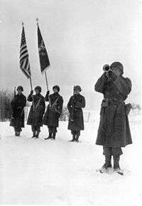
Memorial ceremony for men of Company C, 9th Armored Engineer Battalion. Who were killed during siege of Bastogne, Belgium. Ceremony was held 22 January 1945 at Sarny Les Vigy France. Bugler sounds "taps" as the color guard stands at attention. XX Corps, U.S. Third Army at Carny Les vigy, France, Source US Army
See also
This article is issued from Wikipedia - version of the 11/17/2016. The text is available under the Creative Commons Attribution/Share Alike but additional terms may apply for the media files.