Salvisa, Kentucky
| Salvisa | |
|---|---|
| Census-designated place | |
 Salvisa | |
| Coordinates: 37°55′00″N 84°51′28″W / 37.91667°N 84.85778°WCoordinates: 37°55′00″N 84°51′28″W / 37.91667°N 84.85778°W | |
| Country | United States |
| State | Kentucky |
| County | Mercer |
| Area[1] | |
| • Total | 1.847 sq mi (4.78 km2) |
| • Land | 1.840 sq mi (4.77 km2) |
| • Water | 0.007 sq mi (0.02 km2) |
| Elevation | 807 ft (246 m) |
| Population (2010)[2] | |
| • Total | 420 |
| • Density | 230/sq mi (88/km2) |
| Time zone | Eastern (EST) (UTC-5) |
| • Summer (DST) | EDT (UTC-4) |
| ZIP code | 40372 |
| Area code(s) | 859 |
| GNIS feature ID | 502854[3] |
Salvisa is a census-designated place in Mercer County, Kentucky, United States. Its population was 420 as of the 2010 census.[2] Salvisa is located at the junction of U.S. Route 127 and Kentucky Route 1987, 10.7 miles (17.2 km) north of Harrodsburg.[4] Salvisa has a post office with ZIP code 40372, which opened on April 4, 1825.[5][6]
Salvisa was laid out in 1816.[7]
Climate
The climate in this area is characterized by hot, humid summers and generally mild to cool winters. According to the Köppen Climate Classification system, Salvisa has a humid subtropical climate, abbreviated "Cfa" on climate maps.[8]
References
- ↑ "US Gazetteer files: 2010, 2000, and 1990". United States Census Bureau. 2011-02-12. Retrieved 2011-04-23.
- 1 2 "American FactFinder". United States Census Bureau. Retrieved 2011-05-14.
- ↑ "Salvisa". Geographic Names Information System. United States Geological Survey.
- ↑ State Primary Road System: Mercer County (PDF) (Map). Kentucky Transportation Cabinet. 2011. Retrieved June 12, 2012.
- ↑ "Postmaster Finder - Post Offices by ZIP Code". United States Postal Service. Retrieved June 12, 2012.
- ↑ United States Postal Service (2012). "USPS - Look Up a ZIP Code". Retrieved 2012-02-15.
- ↑ Collins, Lewis (1877). History of Kentucky. p. 603.
- ↑ Climate Summary for Salvisa, Kentucky
Municipalities and communities of Mercer County, Kentucky, United States | ||
|---|---|---|
| Cities | 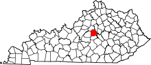 | |
| CDP | ||
| Unincorporated communities | ||
| Ghost town | ||
This article is issued from Wikipedia - version of the 10/19/2016. The text is available under the Creative Commons Attribution/Share Alike but additional terms may apply for the media files.