Sainte-Jeanne-d'Arc, Saguenay–Lac-Saint-Jean, Quebec
Not to be confused with the parish municipality of Sainte-Jeanne-d'Arc, Bas-Saint-Laurent, Quebec.
| Sainte-Jeanne-d'Arc | |
|---|---|
| Village municipality | |
 | |
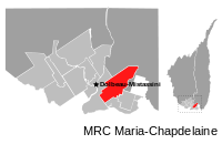 | |
 Sainte-Jeanne-d'Arc Location in Saguenay–Lac-Saint-Jean Quebec. | |
| Coordinates: 48°51′27″N 72°05′38″W / 48.8575°N 72.0939°WCoordinates: 48°51′27″N 72°05′38″W / 48.8575°N 72.0939°W[1] | |
| Country |
|
| Province |
|
| Region | Saguenay–Lac-Saint-Jean |
| RCM | Maria-Chapdelaine |
| Constituted | January 24, 1970 |
| Named for | Joan of Arc[1] |
| Government[2] | |
| • Mayor | Yvan Pilote |
| • Federal riding | Roberval—Lac-Saint-Jean |
| • Prov. riding | Roberval |
| Area[2][3] | |
| • Total | 273.30 km2 (105.52 sq mi) |
| • Land | 269.43 km2 (104.03 sq mi) |
| Population (2011)[3] | |
| • Total | 1,089 |
| • Density | 4.0/km2 (10/sq mi) |
| • Pop (2006–11) |
|
| • Dwellings | 550 |
| Time zone | EST (UTC−5) |
| • Summer (DST) | EDT (UTC−4) |
| Postal code(s) | G0W 1E0 |
| Area code(s) | 418 and 581 |
Sainte-Jeanne-d'Arc is a village in the Canadian province of Quebec, located within the regional county municipality of Maria-Chapdelaine. The village had a population of 1,089 in the Canada 2011 Census.[3]
Demographics
Population trend:[4]
- Population in 2011: 1089 (2006 to 2011 population change: -4.4%)
- Population in 2006: 1139
- Population in 2001: 1128
- Population in 1996: 1158
- Population in 1991: 1113
Private dwellings occupied by usual residents: 467 (total dwellings: 550)
Mother tongue:[5]
- English as first language: 0%
- French as first language: 95.2%
- English and French as first language: 3.9%
- Other as first language: 0.9%
References
- 1 2 Reference number 56219 of the Commission de toponymie du Québec (French)
- 1 2 Ministère des Affaires municipales, des Régions et de l'Occupation du territoire - Répertoire des municipalités: Sainte-Jeanne-d'Arc
- 1 2 3 "Sainte-Jeanne-d'Arc census profile". 2011 Census data. Statistics Canada. Retrieved 2010-11-15.
- ↑ Statistics Canada: 1996, 2001, 2006, 2011 census
- ↑ "Sainte-Jeanne-d'Arc community profile". 2006 Census data. Statistics Canada. Retrieved 2010-11-15.
 |
Passes-Dangereuses | | ||
| Dolbeau-Mistassini | |
Passes-Dangereuses Saint-Augustin | ||
| ||||
| | ||||
| Péribonka |
| Cities & Towns | |
|---|---|
| Municipalities | |
| Parishes | |
| Villages | |
| Unorganized territories | |
| |
This article is issued from Wikipedia - version of the 11/13/2016. The text is available under the Creative Commons Attribution/Share Alike but additional terms may apply for the media files.