Saint-Mandrier-sur-Mer
| Saint-Mandrier-sur-Mer | ||
|---|---|---|
|
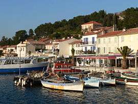
A view of the harbor with the SNSM rescue boat and fishermen's boats | ||
| ||
 Saint-Mandrier-sur-Mer | ||
|
Location within Provence-A.-C.d'A. region  Saint-Mandrier-sur-Mer | ||
| Coordinates: 43°05′00″N 5°56′00″E / 43.0833°N 05.9333°ECoordinates: 43°05′00″N 5°56′00″E / 43.0833°N 05.9333°E | ||
| Country | France | |
| Region | Provence-Alpes-Côte d'Azur | |
| Department | Var | |
| Arrondissement | Toulon | |
| Canton | Saint Mandrier-sur-Mer | |
| Intercommunality | Toulon Provence Méditerranée | |
| Government | ||
| • Mayor (1995–) | Gilles Vincent | |
| Area1 | 5.12 km2 (1.98 sq mi) | |
| Population (2006)2 | 6,636 | |
| • Density | 1,300/km2 (3,400/sq mi) | |
| Time zone | CET (UTC+1) | |
| • Summer (DST) | CEST (UTC+2) | |
| INSEE/Postal code | 830153 / 83430 | |
| Elevation | 0–124 m (0–407 ft) | |
|
1 French Land Register data, which excludes lakes, ponds, glaciers > 1 km² (0.386 sq mi or 247 acres) and river estuaries. 2 Population without double counting: residents of multiple communes (e.g., students and military personnel) only counted once. | ||


Saint-Mandrier-sur-Mer is a commune in the Var department in the Provence-Alpes-Côte d'Azur region in southeastern France.
Across the harbour from the port of Toulon, Saint-Mandrier-sur-Mer is home to a fishing port of its own, tucked into a small inlet.
History
Situated on the Isle de Sépet until a causeway was constructed between 1630 and 1657, what is now the town shows evidence of long habitation. A Phoenician tower once stood on the island, while the area was cleared for farming in the 6th century. The Phoenician tower was converted to a Christian chapel in 566 and the church of Saint-Honorat was built in 1020.
The causeway to the mainland (the isthme des Sablettes) not only led to the creation of an independent town, but the use of the area as a battery station for the heavily fortified port of Toulon. Fishing and naval work dominated the town, with the construction of the "Infirmerie Royale Saint-Louis" naval hospital, becoming the 1818 the "Hôpital Maritime Saint-Mandrier" in 1818. In the 19th century, Saint-Mandrier-sur-Mer also was home to sailmaking. Naval aviation and the Fleet Mechanics and Pilots School (école des Mécaniciens et Chauffeurs de la flotte - GEM) were located in the town in the 1930s.
In World War II, Saint-Mandrier was fortified with two turrets, each mounting a pair of 340mm naval guns taken the French battleship Provence. This fortress controlled the approaches to Toulon, and the range and power of these guns was such that a considerable Allied naval force was required to destroy them. Part of the fleet, and the first to engage the battery, was the Free French battleship Lorraine, sister ship to the Provence and mounting the same type of gun. The Allies termed the battery 'Big Willie', and dedicated a battleship or heavy cruiser to shelling it every day; eventually USS Nevada silenced the guns on August 23, 1944, although the fortress would not be taken until 28th.[1][2]
Economics
Once home to a French Naval Air station, its location near the homeport of the French Navy at Toulon has meant that the military has played a huge economic role in the life of the town. Increasingly, Saint-Mandrier-sur-Mer is focused on the tourist industry.
See also
References
- ↑ Karig, Commander Walter; Burton, Lieutenant Earl; Freeland, Lieutenant Stephen L. (1946). Battle Report (Volume 2); The Atlantic War. New York/Toronto: Farrar and Rinehart, Inc. pp. 386–387.
- ↑ Burton, Earl (September 2004). "The Other D-Day: The Invasion Of Southern France". Sea Classics. 37 (9): 60–70. Retrieved 2009-06-23.
External links
| Wikimedia Commons has media related to Saint-Mandrier-sur-Mer. |
- (French) ville-saintmandrier.fr: official website.
- (English) Provenceweb.fr: Saint Mandrier sur Mer.