Mazaugues
| Mazaugues | ||
|---|---|---|
|
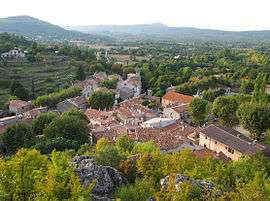
A view of the village from the castle | ||
| ||
 Mazaugues | ||
|
Location within Provence-A.-C.d'A. region  Mazaugues | ||
| Coordinates: 43°20′55″N 5°55′21″E / 43.3486°N 5.9225°ECoordinates: 43°20′55″N 5°55′21″E / 43.3486°N 5.9225°E | ||
| Country | France | |
| Region | Provence-Alpes-Côte d'Azur | |
| Department | Var | |
| Arrondissement | Brignoles | |
| Canton | Roquebrussanne | |
| Intercommunality | Val d'Issole | |
| Government | ||
| • Mayor (2001–2008) | Guy Bagnis | |
| Area1 | 53.79 km2 (20.77 sq mi) | |
| Population (2006)2 | 687 | |
| • Density | 13/km2 (33/sq mi) | |
| Time zone | CET (UTC+1) | |
| • Summer (DST) | CEST (UTC+2) | |
| INSEE/Postal code | 83076 / 83136 | |
| Elevation |
312–1,055 m (1,024–3,461 ft) (avg. 420 m or 1,380 ft) | |
|
1 French Land Register data, which excludes lakes, ponds, glaciers > 1 km² (0.386 sq mi or 247 acres) and river estuaries. 2 Population without double counting: residents of multiple communes (e.g., students and military personnel) only counted once. | ||
.svg.png)
Mazaugues is a commune in the Var department in the Provence-Alpes-Côte d'Azur region in southeastern France.
See also
References
| Wikimedia Commons has media related to Mazaugues. |
This article is issued from Wikipedia - version of the 7/20/2016. The text is available under the Creative Commons Attribution/Share Alike but additional terms may apply for the media files.