Saint-Illide
| Saint-Illide | ||
|---|---|---|
|
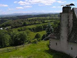
The Monts du Cantal on the horizon, seen from Saint-Illide, with a typical house on the right | ||
| ||
 Saint-Illide | ||
|
Location within Auvergne-Rhône-Alpes region  Saint-Illide | ||
| Coordinates: 45°03′45″N 2°18′57″E / 45.0625°N 2.3158°ECoordinates: 45°03′45″N 2°18′57″E / 45.0625°N 2.3158°E | ||
| Country | France | |
| Region | Auvergne-Rhône-Alpes | |
| Department | Cantal | |
| Arrondissement | Aurillac | |
| Canton | Saint-Cernin | |
| Intercommunality | Pays de Salers | |
| Government | ||
| • Mayor (2008–2014) | François Lachaze | |
| Area1 | 39.71 km2 (15.33 sq mi) | |
| Population (2008)2 | 672 | |
| • Density | 17/km2 (44/sq mi) | |
| Time zone | CET (UTC+1) | |
| • Summer (DST) | CEST (UTC+2) | |
| INSEE/Postal code | 15191 / 15310 | |
| Elevation |
424–733 m (1,391–2,405 ft) (avg. 625 m or 2,051 ft) | |
|
1 French Land Register data, which excludes lakes, ponds, glaciers > 1 km² (0.386 sq mi or 247 acres) and river estuaries. 2 Population without double counting: residents of multiple communes (e.g., students and military personnel) only counted once. | ||

Saint-Illide is a commune in the Cantal department in south-central France.
Population
| Historical population | ||
|---|---|---|
| Year | Pop. | ±% |
| 1962 | 893 | — |
| 1968 | 959 | +7.4% |
| 1975 | 802 | −16.4% |
| 1982 | 717 | −10.6% |
| 1990 | 701 | −2.2% |
| 1999 | 668 | −4.7% |
| 2008 | 672 | +0.6% |
See also
References
| Wikimedia Commons has media related to Saint-Illide. |
This article is issued from Wikipedia - version of the 3/15/2016. The text is available under the Creative Commons Attribution/Share Alike but additional terms may apply for the media files.