Raulhac
| Raulhac | ||
|---|---|---|
|
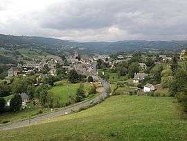
A general view of Raulhac | ||
| ||
 Raulhac | ||
|
Location within Auvergne-Rhône-Alpes region  Raulhac | ||
| Coordinates: 44°54′01″N 2°39′25″E / 44.9003°N 2.6569°ECoordinates: 44°54′01″N 2°39′25″E / 44.9003°N 2.6569°E | ||
| Country | France | |
| Region | Auvergne-Rhône-Alpes | |
| Department | Cantal | |
| Arrondissement | Aurillac | |
| Canton | Vic-sur-Cère | |
| Intercommunality | Cère et Goul en Carladès | |
| Government | ||
| • Mayor (2014–2020) | Philippe Matiere | |
| Area1 | 16.98 km2 (6.56 sq mi) | |
| Population (2008)2 | 337 | |
| • Density | 20/km2 (51/sq mi) | |
| Time zone | CET (UTC+1) | |
| • Summer (DST) | CEST (UTC+2) | |
| INSEE/Postal code | 15159 / 15800 | |
| Elevation |
539–995 m (1,768–3,264 ft) (avg. 740 m or 2,430 ft) | |
|
1 French Land Register data, which excludes lakes, ponds, glaciers > 1 km² (0.386 sq mi or 247 acres) and river estuaries. 2 Population without double counting: residents of multiple communes (e.g., students and military personnel) only counted once. | ||

Raulhac is a commune in the Cantal department in south-central France.
Population
| Year | 1962 | 1968 | 1975 | 1982 | 1990 | 1999 | 2008 |
|---|---|---|---|---|---|---|---|
| Population | 364 | 448 | 386 | 350 | 364 | 332 | 337 |
See also
References
| Wikimedia Commons has media related to Raulhac. |
This article is issued from Wikipedia - version of the 3/15/2016. The text is available under the Creative Commons Attribution/Share Alike but additional terms may apply for the media files.