Saffordville, Kansas
| Saffordville, Kansas | |
|---|---|
| Unincorporated community | |
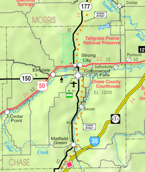 KDOT map of Chase County (legend) | |
 Saffordville  Saffordville | |
| Coordinates: 38°24′0″N 96°23′34″W / 38.40000°N 96.39278°WCoordinates: 38°24′0″N 96°23′34″W / 38.40000°N 96.39278°W | |
| Country | United States |
| State | Kansas |
| County | Chase |
| Government | |
| • Type | Unincorporated |
| Elevation | 1,142 ft (348 m) |
| Time zone | Central (CST) (UTC-6) |
| • Summer (DST) | CDT (UTC-5) |
| Area code(s) | 620 |
| FIPS code | 20-62050[1] |
| GNIS feature ID | 0477269[1] |
Saffordville is an unincorporated community in Chase County, Kansas, United States.
History
For millennia, the land now known as Kansas was inhabited by Native Americans. In 1803, most of modern Kansas was secured by the United States as part of the Louisiana Purchase. In 1854, the Kansas Territory was organized, then in 1861 Kansas became the 34th U.S. state. In 1859, Chase County was founded.
In 1871, the Atchison, Topeka and Santa Fe Railway built a main line east-west through Safford.[2] In 1996, it merged with Burlington Northern Railroad and renamed to the current BNSF Railway. The Santa Fe depot building still exists, but has been closed for decades. Most locals still refer to this railroad as the "Santa Fe".
A post office was established in Safford on December 31, 1872. The post office was renamed to Kenyon on October 27, 1887, then again to Saffordville on October 3, 1888. The post office closed on January 6, 1957.[3]
There has been numerous floods during the history of Saffordville. In June and July 1951, due to heavy rains, rivers and streams flooded numerous cities in Kansas, including Saffordville. Many reservoirs and levees were built in Kansas as part of a response to the Great Flood of 1951.
Saffordville was particularly impacted by the 1951 flood, as the entire town (which had 200 people at the time) was under five feet of water. Residents had to be evacuated, and when the waters receded many of them moved elsewhere, and the town quickly became a ghost town. Today, little remains other than two homes and a schoolbuilding.
Geography
Saffordville is located at 38°24′0″N 96°23′34″W / 38.40000°N 96.39278°W (38.4000138, -96.3927797), in the scenic Flint Hills of the Great Plains. The Cottonwood River is approximately 1 mile south of the community.
Climate
The climate in this area is characterized by hot, humid summers and generally mild to cool winters. According to the Köppen Climate Classification system, Saffordville has a humid subtropical climate, abbreviated "Cfa" on climate maps.[4]
Education

Primary and secondary education
Cottonwood Falls is part of Unified School District 284.[5][6] All students attend schools in Cottonwood Falls.
- Chase County Junior/Senior High School, 600 Main St in Cottonwood Falls.
- Chase County Elementary School, 401 Maple St in Cottonwood Falls.
Transportation
U.S. Route 50 highway passes near Saffordville, and BNSF Railway passes through it.
Notable people
- Fred Brickell, professional baseball player
See also
Further reading
References
- 1 2 "US Board on Geographic Names". United States Geological Survey. 2007-10-25. Retrieved 2008-01-31.
- ↑ Santa Fe Rail History
- ↑ "Kansas Post Offices, 1828-1961 (archived)". Kansas Historical Society. Archived from the original on October 9, 2013. Retrieved 5 June 2014.
- ↑ Climate Summary for Saffordville, Kansas
- ↑ USD 284
- ↑ Kansas School District Boundary Map
External links
| Wikimedia Commons has media related to Saffordville, Kansas. |
- USD 284, school district for all of Chase County.
- Saffordville - A "Quiet" town of Chase County, Kansas, History and photographs.
- Maps
- Chase County Maps: Current, Historic, KDOT
- Topo Map of Saffordville / Ellinor area, USGS
Municipalities and communities of Chase County, Kansas, United States | ||
|---|---|---|
| Cities | 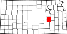 | |
| Unincorporated communities | ||
| Ghost towns | ||
| Townships | ||
| Footnotes | ‡This populated place also has portions in an adjacent county or counties | |