Södertörn
Coordinates: 59°01′01″N 17°53′11″E / 59.01699°N 17.88637°E
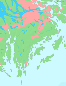
Södertörn is a roughly triangular island in eastern Södermanland, Sweden, which is bordered by:
- Lake Mälaren and the inlet of Saltsjön (a part of Baltic Sea) to the north,
- Himmerfjärden and Hallsfjärden (parts of Baltic Sea) to the west and
- The Baltic Sea (Stockholm Archipelago) to the east and the south.
- The Södertälje Canal to the south west.
Since 2005, the whole of Södertörn has been included in Greater Stockholm. Before that, the southern parts of the island, which lie within Nynäshamn municipality, and the western parts, which are in Södertälje were not part of Greater Stockholm.
The northern areas of Södertörn are to a large extent made up of rift-valley countryside (and urban areas) with high ground which is either pine forest or bare. The long valleys of the south become level ground, while those in the north contain salt water. The bedrock is almost entirely gneiss.
The island's name (á [...] Taurinum in 1225, Tør in 1283, a Tørinne in 1383 and eventually ‘‘Södertörn’’ since 1645) derives from the Old Norse dialect word tor, meaning "broken rocky beaches", which cut deep into the coast of Södertörn.
The highest point on Södertörn is Tornberget (in Haninge municipality) at 110.9 metres (363.8 feet) above sea level. It is located in Hanveden, a large area of forest south of Stockholm, which eastern areas partially form the Tyresta National Park.
The southernmost parts of Södertörn were connected to Stockholm in 1901, when the Nynäs railway line was opened. The railway runs between Nynäshamn in the south and Älvsjö in the north, where it joins to the main southern railway.
Municipalities of Södertörn
- Botkyrka
- Haninge
- Huddinge
- Nacka (west of Skurusundet)
- Nynäshamn
- Salem
- Söderort, the southern part of Stockholm Municipality
- Södertälje (east of the Södertälje Canal)
- Tyresö
All these municipalities are located both in Stockholm County and the province Södermanland. Though incorrect, the two remaining municipalities to fulfil these criteria — Södertälje and Nykvarn — both located west of Södertälje Canal, are sometimes also thought of as part of Södertörn.
See also
| Wikivoyage has a travel guide for Södertörn. |