Sé (Funchal)
| Sé | ||
| Civil Parish | ||
 Central Funchal in the parish of Sé, looking towards the marina | ||
|
||
| Official name: Freguesia da Sé | ||
| Name origin: Portugues for Episcopal see | ||
| Country | ||
|---|---|---|
| Region | ||
| Island | Madeira | |
| Municipality | Funchal | |
| Center | Sé | |
| - elevation | 34 m (112 ft) | |
| - coordinates | 32°38′46″N 16°54′51″W / 32.64611°N 16.91417°WCoordinates: 32°38′46″N 16°54′51″W / 32.64611°N 16.91417°W | |
| Lowest point | ||
| - elevation | 0 m (0 ft) | |
| Area | 3.82 km2 (1 sq mi) | |
| Population | 2,656 (2011) | |
| Density | 695/km2 (1,800/sq mi) | |
| Settlement | c. 1415 | |
| - Parish | c. 1514 | |
| - Civil Parish | c. 1566 | |
| LAU | Junta Freguesia | |
| - location | Travessa dos Reis | |
| President Junta | Alcino Rodrigues Ferreira (PPD-PSD) | |
| President Assembleia | Jorge Manuel da Silva Morgado (PPD-PSD) | |
| Timezone | WET (UTC0) | |
| - summer (DST) | WEST (UTC+1) | |
| Postal Zone | 9050-443 | |
| Area Code & Prefix | (+351) 291 XXX XXX | |
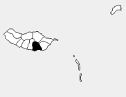 Location of the parish seat of Sé in the municipality of Funchal, island of Madeira | ||
| Wikimedia Commons: Sé (Funchal) | ||
| Statistics from INE (2001); geographic detail from Instituto Geográfico Português (2010) | ||


The Cathedral of Funchal, in the center of the Sé parish.
Sé (Portuguese for Episcopal see) is a civil parish in the municipality of Funchal in the Autonomous Region of Madeira. It includes the historical centre of Funchal. The population in 2011 was 2,656,[1] in an area of 3.82 km².[2] Its administrative authority includes the distant, uninhabited Savage Islands, with an area of 2.73 km².
References
This article is issued from Wikipedia - version of the 6/24/2014. The text is available under the Creative Commons Attribution/Share Alike but additional terms may apply for the media files.