Rye railway station
| Rye | |
|---|---|
 | |
| Location | |
| Place | Rye |
| Local authority | Rother |
| Grid reference | TQ918205 |
| Operations | |
| Station code | RYE |
| Managed by | Southern |
| Number of platforms | 2 |
| DfT category | E |
|
Live arrivals/departures, station information and onward connections from National Rail Enquiries | |
| Annual rail passenger usage* | |
| 2010/11 |
|
| 2011/12 |
|
| 2012/13 |
|
| 2013/14 |
|
| 2014/15 |
|
| History | |
| Key dates | Opened 13 February 1851 |
| National Rail – UK railway stations | |
| * Annual estimated passenger usage based on sales of tickets in stated financial year(s) which end or originate at Rye from Office of Rail and Road statistics. Methodology may vary year on year. | |
|
| |
Rye railway station serves Rye in East Sussex, England. It is on the Marshlink Line 11 1⁄4 miles (18.1 km) east of Hastings providing a passing place between two single track sections. Train services are provided by Southern. The staggered platforms are linked by footbridge. Owing to a prolonged threat by British Rail to close the line, the station remained unmodernised and gaslit well into the 1970s.
History
The station opened on 13 February 1851, six weeks before the 1851 census. The census lists the station master as 23-year-old James Broderick from London. In each of the four successive censuses, William Hunt from Devon is named as station master, indicating at least a 40-year spell in charge. In 1901 it shows Richard Hunnisett as station master and in 1911 it is George Geer.
Services
The typical off-peak service is one train per hour to Hastings and Brighton and one train per hour to Ashford International.
At peak times an Ashford to Rye shuttle also operates meaning that between 0600 and 0900 six trains operate towards Ashford International and the wider network of services available there. In the reverse direction in the evening some six trains operate between 1730 and 2000.
| Preceding station | |
Following station | ||
|---|---|---|---|---|
| Winchelsea | Southern Marshlink Line |
Appledore (Kent) | ||
Gallery

 View of Platform 1 (Ashford-bound) from the footbridge
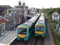 Marshlink Line trains are booked to pass at Rye
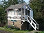 The station's signal box, opposite Platform 2 (Brighton-bound platform)
External links
- Train times and station information for Rye railway station from National Rail
Coordinates: 50°57′07″N 0°43′52″E / 50.952°N 0.731°E