Robertsbridge railway station
| Robertsbridge | |
|---|---|
 | |
| Location | |
| Place | Robertsbridge |
| Local authority | Rother |
| Grid reference | TQ733235 |
| Operations | |
| Station code | RBR |
| Managed by | Southeastern |
| Number of platforms | 2 |
| DfT category | E |
|
Live arrivals/departures, station information and onward connections from National Rail Enquiries | |
| Annual rail passenger usage* | |
| 2004/05 | 0.213 million |
| 2005/06 |
|
| 2006/07 |
|
| 2007/08 |
|
| 2008/09 |
|
| 2009/10 |
|
| 2010/11 |
|
| 2011/12 |
|
| 2012/13 |
|
| 2013/14 |
|
| 2014/15 |
|
| History | |
| 1 September 1851 | Opened |
| National Rail – UK railway stations | |
| * Annual estimated passenger usage based on sales of tickets in stated financial year(s) which end or originate at Robertsbridge from Office of Rail and Road statistics. Methodology may vary year on year. | |
|
| |

Robertsbridge railway station is on the Hastings Line in East Sussex in England, and serves Robertsbridge. Train services are provided by Southeastern.
History

Robertsbridge was temporarily the terminus of the South Eastern Railway's (SER) "Hastings Line" from Tunbridge Wells. This section was opened on 1 September 1851, with the 5.99 mile (9.64 km)[1] stretch to Battle following four months later. A connection was then made with the existing route to Hastings on 1 February 1852;[2] the line connecting St Leonards (West Marina) with Hastings having been opened by the SER on 13 February 1851, and which initially gave the Brighton, Lewes and Hastings Railway access to the latter town.[3] A large station building was provided on the Down side, along with a signal box at the south end of the Down platform.
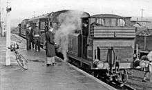
Robertsbridge became a junction in 1900 with the opening of the Rother Valley Light Railway to Tenterden. The line was extended to Headcorn in 1905, and was renamed the Kent and East Sussex Railway. In 1954 all regular passenger services were withdrawn and the line beyond Tenterden Town was completely closed. The line to Tenterden continued to be used by freight services and occasional special passenger trains (e.g. hop pickers trains) until closed by British Railways on 12 June 1961. About half a mile length of line remained in use as a siding to serve Hodsons Mill on the outskirts of Robertsbridge until 1970.The bay platform, on the Down (eastern) side of the station, is still in place and used for engineers trains. A railway preservation society, the Rother Valley Railway, is in progress in constructing a new separate station on the east side of the car park, and have rebuilt the line from here to Northbridge Street. The first train on this rebuilt section ran in September 2013. They have plans to rebuild the rest of the route eastwards to join up with the Kent and East Sussex Railway and restore services along the line. (Steam trains already run on another section of the line, between Tenterden Town and Bodiam, 3½ miles from Robertsbridge.)
Services
The typical off-peak service is one train per hour to London Charing Cross via Tunbridge Wells, and one train per hour to Hastings.[4]
| Preceding station | |
Following station | ||
|---|---|---|---|---|
| Etchingham | Southeastern Hastings Line Stopping |
Battle | ||
| Disused railways | ||||
| Salehurst Halt | British Rail Southern Region KESR |
Terminus | ||
| Etchingham | Southern Railway Hastings Line |
Mountfield Halt Towards Hastings | ||
Gallery
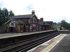
 General view from the footbridge
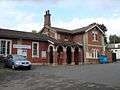 Frontage of the station building
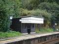 Wooden waiting shelter on Platform 1
 The former bay platform and goods depot
References
- ↑ Marsden, Colin J (1985). Route Recognition: 1 — Southern Region (page 96). Ian Allan Ltd, Shepperton. ISBN 0-7110-1553-8.
- ↑ Body, Geoffrey. PSL Field Guide – Railways of the Southern Region (1984), pages 161-162. Patrick Stephens Ltd, Cambridge. ISBN 0-85059-664-5
- ↑ Dendy Marshall, C.F.; Kidner, R.W. (1963) [1937]. History of the Southern Railway (2nd ed.). Shepperton: Ian Allan. p. 204. ISBN 0-7110-0059-X.
- ↑ Network Rail Timetable May 2010: Table 206
External links
- Train times and station information for Robertsbridge railway station from National Rail
Coordinates: 50°59′06″N 0°28′08″E / 50.985°N 0.469°E