Rote, Pennsylvania
| Rote, Pennsylvania | |
|---|---|
| Census-designated place | |
 Location in Clinton County and the state of Pennsylvania. | |
| Coordinates: 41°04′44″N 77°25′12″W / 41.07889°N 77.42000°WCoordinates: 41°04′44″N 77°25′12″W / 41.07889°N 77.42000°W | |
| Country | United States |
| State | Pennsylvania |
| County | Clinton |
| Township | Lamar |
| Area | |
| • Total | 1.1 sq mi (2.8 km2) |
| • Land | 1.1 sq mi (2.8 km2) |
| • Water | 0.0 sq mi (0.0 km2) |
| Elevation | 755 ft (230 m) |
| Population (2010) | |
| • Total | 507 |
| • Density | 466/sq mi (179.9/km2) |
| Time zone | Eastern (EST) (UTC-5) |
| • Summer (DST) | EDT (UTC-4) |
| ZIP code | 17751 |
| FIPS code | 42-66384 |
| GNIS feature ID | 2630037 |
Rote is a census-designated place[1] located in Lamar Township in southern Clinton County, Pennsylvania, United States. As of the 2010 census the population was 507.[2]
Rote is located near the center of Lamar Township in southern Clinton County, along Pennsylvania Route 477 near the northeastern end of the Nittany Valley. PA 477 leads west 3 miles (5 km) to U.S. Route 220 at Cedar Springs, and east 7 miles (11 km) to Exit 185 on Interstate 80 near Loganton. Exit 178 on I-80 is 2.5 miles (4.0 km) southwest of Rote, via a local road and US 220.
References
- ↑ http://www.census.gov/2010census/
- ↑ "Geographic Identifiers: 2010 Census Summary File 1 (G001): Rote CDP, Pennsylvania". U.S. Census Bureau, American Factfinder. Retrieved May 19, 2015.
External links
Municipalities and communities of Clinton County, Pennsylvania, United States | ||
|---|---|---|
| City | 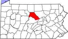 | |
| Boroughs | ||
| Townships | ||
| CDPs | ||
| Unincorporated communities | ||
| Footnotes | ‡This populated place also has portions in an adjacent county | |
This article is issued from Wikipedia - version of the 6/13/2016. The text is available under the Creative Commons Attribution/Share Alike but additional terms may apply for the media files.