Roanoke, Alabama
| Roanoke, Alabama | |
|---|---|
| City | |
|
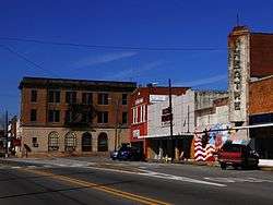
Downtown Roanoke, Alabama | |
 Location in Randolph County and the state of Alabama | |
| Coordinates: 33°8′56″N 85°22′11″W / 33.14889°N 85.36972°W | |
| Country | United States |
| State | Alabama |
| County | Randolph |
| Government | |
| • Mayor | Mike Fisher |
| Area | |
| • Total | 19.1 sq mi (49.4 km2) |
| • Land | 18.8 sq mi (48.7 km2) |
| • Water | 0.3 sq mi (0.7 km2) |
| Elevation | 840 ft (256 m) |
| Population (2010) | |
| • Total | 6,074 |
| • Density | 343.6/sq mi (132.9/km2) |
| Time zone | Central (CST) (UTC-6) |
| • Summer (DST) | CDT (UTC-5) |
| ZIP code | 36274 |
| Area code(s) | 334 |
| FIPS code | 01-65040 |
| GNIS feature ID | 0153164 |
Roanoke is a city in Randolph County, which is in the Piedmont region of eastern Alabama, United States. As of the 2010 census, the population of the city is 6,074, down from 6,563 in 2000.
History
This was an area of historic occupation by the Creek before treaties to persuade the Native Americans to cede their land, followed by forced migration under the Indian Removal Act of 1830. The area was part of a broad part of upland developed as cotton plantations worked by enslaved African Americans. The area is still quite rural.
Initially called High Pine in the 1830s after a nearby creek, it was allegedly burned during an Indian uprising in 1836. Renamed Chulafinee in 1840, it was later renamed again for the hometown of one of the early settlers, Roanoke, Virginia. The city was officially incorporated in December 1890.[1]
Geography
Roanoke is located at 33°8′56″N 85°22′11″W / 33.14889°N 85.36972°W (33.148830, -85.369784).[2]
According to the U.S. Census Bureau, the city has a total area of 19.1 square miles (49 km2), of which 18.8 square miles (49 km2) is land and 0.3 square miles (0.78 km2) (1.47%) is water.
Local
The Mayor has been Mike Fisher since 2009.
Roanoke has three schools served by Roanoke City Schools: Knight Enloe Elementary (K-3), Handley Middle School (4-8), and Handley High School (9-12). On December 1, 2011, the Handley Tigers won the AHSAA Football Class 3A State Championship.[3]
Roanoke is served by a weekly newspaper, The Randolph Leader.[4]
Demographics
| Historical population | |||
|---|---|---|---|
| Census | Pop. | %± | |
| 1880 | 327 | — | |
| 1890 | 631 | 93.0% | |
| 1900 | 1,155 | 83.0% | |
| 1910 | 2,034 | 76.1% | |
| 1920 | 3,841 | 88.8% | |
| 1930 | 4,373 | 13.9% | |
| 1940 | 4,168 | −4.7% | |
| 1950 | 5,392 | 29.4% | |
| 1960 | 5,288 | −1.9% | |
| 1970 | 5,251 | −0.7% | |
| 1980 | 5,809 | 10.6% | |
| 1990 | 6,362 | 9.5% | |
| 2000 | 6,563 | 3.2% | |
| 2010 | 6,074 | −7.5% | |
| Est. 2015 | 6,005 | [5] | −1.1% |
| U.S. Decennial Census[6] 2013 Estimate[7] | |||
As of the census[8] of 2000, there were 6,563 people, 2,467 households, and 1,660 families residing in the city. The population density was 348.9 people per square mile (134.7/km²). There were 2,792 housing units at an average density of 148.4 per square mile (57.3/km²). The racial makeup of the city was 58.94% White, 39.77% Black or African American, 0.06% Native American, 0.26% Asian, 0.34% from other races, and 0.64% from two or more races. 1.19% of the population were Hispanic or Latino of any race.
There were 2,467 households out of which 30.6% had children under the age of 18 living with them, 46.9% were married couples living together, 17.3% had a female householder with no husband present, and 32.7% were non-families. 30.2% of all households were made up of individuals and 13.5% had someone living alone who was 65 years of age or older. The average household size was 2.51 and the average family size was 3.12.
In the city the population was spread out with 26.0% under the age of 18, 8.7% from 18 to 24, 25.3% from 25 to 44, 20.8% from 45 to 64, and 19.2% who were 65 years of age or older. The median age was 37 years. For every 100 females there were 86.8 males. For every 100 females age 18 and over, there were 79.4 males.
The median income for a household in the city was $26,946, and the median income for a family was $32,405. Males had a median income of $29,594 versus $22,135 for females. The per capita income for the city was $14,088. About 11.9% of families and 18.6% of the population were below 7% of those younger than 18 and 15.8% of those age 65 or older.
2010 census
As of the census[9] of 2010, there were 6,074 people, 2,409 households, and 1,538 families residing in the city. The population density was 323.1 people per square mile (124.7/km²). There were 2,817 housing units at an average density of 149.8 per square mile (57.8/km²). The racial makeup of the city was 57.6% White, 40.5% Black or African American, 0.2% Native American, 0.6% Asian, 0.2% from other races, and 0.9% from two or more races. 1.2% of the population were Hispanic or Latino of any race.
There were 2,409 households out of which 29.1% had children under the age of 18 living with them, 38.1% were married couples living together, 21.8% had a female householder with no husband present, and 36.2% were non-families. 33.1% of all households were made up of individuals and 15.5% had someone living alone who was 65 years of age or older. The average household size was 2.45 and the average family size was 3.11.
In the city the population was spread out with 26.9% under the age of 18, 8.0% from 18 to 24, 23.5% from 25 to 44, 24.5% from 45 to 64, and 17.2% who were 65 years of age or older. The median age was 37.8 years. For every 100 females there were 80.0 males. For every 100 females age 18 and over, there were 83.4 males.
The median income for a household in the city was $30,073, and the median income for a family was $37,007. Males had a median income of $35,096 versus $31,406 for females. The per capita income for the city was $20,286. About 25.8% of families and 31.0% of the population were below 47.7% of those younger than 18 and 13.5% of those age 65 or older.
Notable people
- Admiral Edward A. Burkhalter, Chief of Naval Intelligence; Director of Intelligence Community, CIA
- Wilkie Clark, African-American entrepreneur and civil rights activist
- Jake Daniel, former Major League Baseball player
- Horace Gillom, former Cleveland Browns football player, who contributed to the evolution of punting by standing farther back from the center than was normal at the time
- William Anderson Handley, former congressman
- Fred Hyatt, former Auburn University and professional football wide receiver
- Odell McLeod, country-gospel singer, radio entertainer, and songwriter
- Stanley O'Neal, former chairman and chief executive officer of Merrill Lynch
- Clare Purcell, former bishop of the Methodist Episcopal Church, South, and the Methodist Church
- Ella Gaunt Smith, doll manufacturer
- David Vann, mayor of Birmingham, Alabama
References
- ↑ http://www.encyclopediaofalabama.org/article/h-3074
- ↑ "US Gazetteer files: 2010, 2000, and 1990". United States Census Bureau. 2011-02-12. Retrieved 2011-04-23.
- ↑ AHSAA. "AHSAA Football Past State Champions".
- ↑
- ↑ "Annual Estimates of the Resident Population for Incorporated Places: April 1, 2010 to July 1, 2015". Retrieved July 2, 2016.
- ↑ "U.S. Decennial Census". Census.gov. Retrieved June 6, 2013.
- ↑ "Annual Estimates of the Resident Population: April 1, 2010 to July 1, 2013". Retrieved June 3, 2014.
- ↑ "American FactFinder". United States Census Bureau. Retrieved 2008-01-31.
- ↑ "American FactFinder". United States Census Bureau. Retrieved 2015-08-07.
External links
- "Roanoke, AL", Library of Congress
Coordinates: 33°08′56″N 85°22′11″W / 33.14883°N 85.369784°W
Municipalities and communities of Randolph County, Alabama, United States | ||
|---|---|---|
| City | 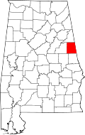 | |
| Towns | ||
| CDPs | ||
| Unincorporated communities | ||