River Tummel
The River Tummel (Scottish Gaelic: Teimhil / Abhainn Teimhil) is a river in Perth and Kinross, Scotland.
Description
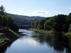
Discharging from Loch Rannoch, it flows east to a point near the Falls of Tummel, where it bends to the southeast, a direction which it maintains until it falls into the River Tay, just below Logierait, after a course of 58 miles (93 km) from its source in Stob Ghabbar (3,565 ft (1,087 m)). Its only considerable affluent is the Garry, 24 miles (39 km) long, an impetuous river which issues from Loch Garry (2.5 mi (4.0 km) and 1,334 ft (407 m) above sea level). About midway in its course the Tummel expands into Loch Tummel (2.75 mi (4.43 km) long, 128 ft (39 m) deep and 500 ft (150 m) above sea level), between which and the confluence with the Garry occur the Pass and Falls of the Tummel, which are rather in the nature of rapids, the descent altogether amounting to 15 ft (4.6 m).[1]

The scenery throughout this reach is most picturesque, culminating at the point above the eastern extremity of the loch, known as the "Queen's View" (Queen Victoria made the view famous in 1866, although it is probably named after Queen Isabel, wife of Robert the Bruce). The chief places of interest on the river are Kinloch Rannoch; Dunalastair, a rocky hill in well-wooded grounds, the embellishment of which was largely due to Alexander Robertson of Struan, the Jacobite and poet, from whom the spot takes its name (the stronghold of Alexander); Foss; Faskally House (beautifully situated on the left bank); Pitlochry; and Ballinluig.[1]
Notes
- 1 2 Chisholm 1911, p. 370.
References
-
 This article incorporates text from a publication now in the public domain: Chisholm, Hugh, ed. (1911). "Tummel". Encyclopædia Britannica. 27 (11th ed.). Cambridge University Press. p. 370.
Coordinates: 56°38′N 3°40′W / 56.633°N 3.667°W