River Nith
| River Nith | |
|---|---|
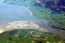 The estuary of the River Nith, opening into Solway Firth south of Dumfries | |
| Country | Scotland |
| Basin | |
| Main source |
Enoch Hill 55°19′41″N 4°17′02″W / 55.328°N 4.284°W |
| River mouth | Solway Firth |
| Basin size | 1,230 km2 (470 sq mi)[1] |
| Physical characteristics | |
| Length | 71 mi (114 km)[2] |
- For the river in southwestern Ontario, see Nith River.
The River Nith (Scottish Gaelic: Abhainn Nid; Latin: Novius[3]) is a river in South West Scotland.
Source, flow and mouth
The Nith rises in the Carsphairn hills of East Ayrshire, more precisely between Prickeny Hill and Enoch Hill, 7 km east of Dalmellington.[4] For the majority of its course it flows in a generally southern direction through Dumfries and Galloway, before spilling into the Solway Firth at Ards point.[4]
The territory through which the river flows is called Nithsdale (historically known as "Stranit" from Scottish Gaelic: Strath Nid, "valley of the Nith").
Length
For estuaries the principle followed is that the river should be visible at all times. The measurement therefore follows the centre of the river at low tide and the mouth of the river is assumed to be at the coastal high tide mark. In Scotland this does not generally make a significant difference, except for rivers draining into shallow sloping sands of the Irish Sea and Solway Firth, notably the Nith. At low tide, the sea recedes to such an extent that the length of the Nith is extended by 13 km to 113.8 km (70.7 miles), making it Scotland's seventh longest river.
Protected areas
The estuary of the River Nith is an important site for wildfowl, and is protected at an international level as part of the Upper Solway Flats and Marshes Ramsar site and Special Protection Area, and as part of the Solway Firth Special Area of Conservation. At a national level, the area is a Site of Special Scientific Interest and is within the Caerlaverock National Nature Reserve.[5]
The Nith Estuary National Scenic Area recognises the scenic value of the area.[6]
Tributaries
Upstream to Downstream:
- Connel Burn
- Afton Water
- Kello Water
- Crawick Water
- Euchan Water
- Mennock Water
- Carron Water
- Cample Water
- Scar Water
- Shinnel Water
- Cluden Water
- Cargen Pow
- New Abbey Pow
Settlements


References
- ↑ "The River Nith Catchment Management Plan" Scottish Environment Protection Agency
- ↑ "River Nith (East Ayrshire)"
- ↑ 'Celtic Scotland' advertisement on google books
- 1 2 "Almanac of Scotland"
- ↑ "Caerlaverock: Designations". Scotland's National Nature Reserves. Retrieved 16 April 2012.
- ↑ "Nith Estuary National Scenic Area". Scotland’s Scenic Heritage. Countryside Commission for Scotland. 1978. Retrieved 16 April 2012.
External links
- Nith Estuary National Scenic Area, South West Scotland Hill Walking Routes
Coordinates: 55°00′N 3°36′W / 55.000°N 3.600°W