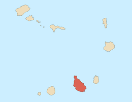
Ribeira Grande de Santiago (stream)
| Ribeira Grande de Santiago | |
|---|---|
|
The valley of Ribeira Grande de Santiago | |
| Country | Cape Verde |
| Basin | |
| Main source |
southwest of São Domingos Santiago Island, Cape Verde 750 m (2,460 ft) |
| River mouth |
Cidade Velha 14°54′51″N 22°36′19″W / 14.9142°N 22.6054°WCoordinates: 14°54′51″N 22°36′19″W / 14.9142°N 22.6054°W |
| Physical characteristics | |
| Length | 15 km (9.3 mi) |
.jpg)
Ribeira Grande de Santiago (Portuguese for a large stream) is a stream that flows in the southern part of the island of Santo Antão in Cape Verde, the upper portion is called Ribeira Cadacina. The stream flows south with one exception in the area of the municipal boundaries and is about 14 to 15 km in length, there are no tributaries but one in the area of Calabaceira. During dry days especially in the Spring and Summer, the stream is predominantly dry.
Geography
The stream as Ribeira Cadacina starts from the agricultural and mountainous portion of the south of the island around Achada Louro (or Massapé) in the municipality of São Domingos inside the boundaries of Pico da Antónia Natural Park. The road (EN3-ST07) linking Ribeira Grande with Rui Vaz and São Domingos runs within the left bank of the river, the road serves Ribeira Grande with the middle and the north of the island. It flows east of Monte Redondos (652 meters) at 540 meters, the municipal boundary at around 450 meters, the Salineiro Reservior at 260 meters where the stream continues as Ribeira Grande de Santiago and at about 250 meters at the dam. At 209 meters, plantations starts to appear particularly baobabs, cocoa, sugar and mangoes grown for centuries, there the river steeps a bit town where it is 140 meters near Salineiro where there area two bends and 100 meters west of Calabaceira, it enters the Cidade Velha urban area at 40 meters and has a right bend, at 20 meters, nearby is Fort Real de São Filipe, it crosses Rua Calhau, a road linking Praia and Porto Mosquito at 3 meters and empties into the Atlantic just south. For a kilometer, a street named after the river runs on the river.
History

During the Ice Age, the stream was about a kilometer longer and was 16 km it shortened to 15 km between 4000 and 3000 BC.
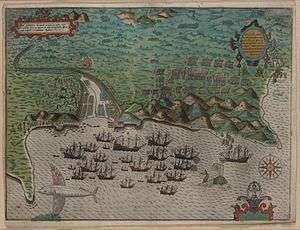
The earlier landscape around Ribeira Grande is unknown. The island along with the river was discovered in 1460 and Cape Verde's first settlement Ribeira Grande (now known as Cidade Velha was founded at the lower portion of the stream. In 1578, the first English corsairs and pirates attacked Ribeira Grande (now Cidade Velha). Later in 1585, as part of the Capture of Santiago, Cidade Velha was damaged during raid by English corsair Sir Francis Drake,[1] and was part of the Anglo-Spanish War (1585), its ships were below the mouth of the stream. After the attacks, the plans for Fort Real de São Filipe started, the fort was completed in 1593, the first in the nation and is to the east bank. An engraving about the raid on Ribeira Grande (common name was Cape Verde City or Cidade de Cabo Verde, now Cidade Velha) was made by Giovanni Battista Boazio in 1589 and was first engraving and its hand colored made about Cape Verde or any of its islands.
In 1712, Cidade Velha was destroyed for the final time by French corsairs commanded by Jacques Cassard in the Cassard expedition, because of the raid, the capital was partly moved east to Praia, the name became Cidade Velha. Praia was not an official capital of the island and the colony until 1770.
Until 2005, the lower portion of the stream formed a part of the municipality of Praia, it became a part of its own municipality.
In 2009 along with the southernmost part of the lower portion of the stream, Cidade Velha including its historic landmarks became the country's only UNESCO's World Heritage Site.[2] Not long after, it became the Seven Wonders of the Portuguese-built Landmark in the World.
In 2011, a dam located upstream from Salineiro started construction and was finished on June 30, 2013,[3] its supplies water to its plantations and nearby areas.
Recently parts of the area within the stream are partly forested. Agriculture is the chief industry inside and within the stream.
See also
References
- ↑ Keeler, Mary Frear (1999). Sir Francis Drake's West Indian Voyage, 1585-86 (Second Series). Hakluyt Society. ISBN 978-0904180015.
- ↑ "Cidade Velha, Historic Centre of Ribeira Grande - UNESCO World Heritage Centre". Retrieved 8 July 2011.
- ↑ "Barragem de Salineiro é inaugurada hoje" [Salineiro Dam to Open Today]. A Semana (in Portuguese). 29 June 2013. Retrieved 11 November 2013.
Geography, features and topics of Santiago and the surrounding islets | ||
|---|---|---|
| Topics |
|  |
| Mountains |
| |
| Streams |
| |
| Points and promontories |
| |
| Reservoirs |
| |
| Other geographic features | ||
| History | ||
| Communities and settlements |  | |
|---|---|---|
| Geographical features | ||
| Culture | ||
| Communities and settlements |
|  |
|---|---|---|
| Geographical features | ||
| Landmarks and points of Interests |
| |
| History | ||