History of Santiago, Cape Verde
This article is about the history of the island of Santiago, Cape Verde, it is one of the longest and the most richest in all of Cape Verde.
Prehistoric era
During the Prehistoric era, around 22 to 21 million years ago, the seamount was formed, 4 to 3 million years ago, the island with its crater now known as Pico da Antónia was formed, its length was about 15 km, about 2 to 3 million years ago, another island with its crater at present day Serra da Malagueta was formed, its seamount was formed around 20 to 19 million years ago, its length was about 10 km, about 2 to 1 million years ago, the two islands merged into a larger island. In about 73,000 BC, the eastern portion of the island of Fogo collapsed into the ocean and brought a 170 meter high megatsunami that flooded the western part of the island.[1] During the Ice Age, the island was larger than 1,050 km² and approximately 80 km wide.
Colonial and provincial Santiago Island

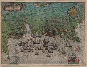


The island was discovered by the explorer António da Noli in around 1460 who built a garrison in Cidade Velha which was then known as Ribeira Grande, it was the first settlement in Cape Verde and was a Portuguese colony until 1975. Transcontinental slavery made Cidade Velha the second richest city in the Portuguese realm. The city was also an exporter of sugar and cloth. Later, Portugal faced competition by the English, Dutch, French and Spanish who gradually took over the slave trade The main part of the south of the island was forested, they were cleared for farming and some of them became groves. Cape Verde's first pillory was constructed in 1520. Villages were founded in the middle of the island around the mid 16th century and decades later in the north São Domingos was established and later Assomada and Pedra Badejo. The Sé Cathedral started being built in 1555, construction was completely stopped and not for over a century it resumed and would be completed in 1699. The Philippine Dynasty came to power in 1585 which would last into 1645 and not until the 1650s when an indepedennt Portuguese administration was restored. The island was captured by Francis Drake,[2] as a result, Fort Real de São Filipe, Cape Verde's first fortress was built on November 17, 1585 and was finished in 1590, São Domingos was also looted.[3][4] and on November 28 Porto Praya (now Praia) razed, only the town hospital was spared, the fleet left after November, this was part of the Anglo-Spanish War (1585). An engraving on the raid on Ribeira Grande (common name was Cape Verde City or Cidade de Cabo Verde, now Cidade Velha) was finished by Giovanni Battista Boazio and was the first engraving and its hand colored made about Cape Verde or any of its island. In 1615 in the area of the southeasternmost part of the island, Praia de Santa Maria appeared on the previous settlement on the plateau, decades later, it would become known as Porto Praya and Porto Praia and is now known as Praia. Cidade Velha along with its fort in 1712 were attacked and destroyed by French corsairs commanded by Jacques Cassard in the Cassard expedition, as of this, CIdade Velha was no longer capital and was moved to the Praia plateau, Praia was not officially capital status until 1770. Though Portugal was neutral throughout the conflict (Anglo-French War, American Revolutionary War), the Battle of Porto Praya took place off modern day Praia at Praia Harbor on April 16, 1780 and the island between Great Britain and France, it ended in a French victory. Cotton first produced in the island of Santiago in around 1794, it was made by the colonial governor José da Silva Maldonado de Eça.[5]
A rebellion led by Manuel António Martins who later became governor took place in Praia which overthrew António Pusich and put João da Mata Chapuzet to power, the next governor made the island and the colonial capital underwent a large modernization of the city, one of the buildings he designed was Quartel Jaime Mota,[6] construction started on May 8, 1822 and was finished in 1826. The island was visited by scientist and naturalist Charles Darwin on the HMS Beagle and visited the island along with Praia (then as Porto Praya),[7] he later visited Ilhéu de Santa Maria[8] before he headed to the islands off the northeast coast of Brazil. A plan to move the colonial seat to Picos which was done by Manuel António Martins was made on February 14, 1834, this had never happened, only the residence moved temporarily in 1855,[9] lastly with Mindelo on São Vicente flourishing with its coal refueling, a plan to move the capital from Praia was done not long after, as Praia was elevated to a city, the capital stayed. Martins was removed from power in 1835 after the Fonteana rebellion (not related to the later colonial governor but a nearby village in Assomada). Two notable American visits were made to the island by USS Yorktown along with William Harwar Parker, first in 1849 where several officers rotated off the ship and Parker became Acting Master and lastly in 1850 where it returned and later left for Funchal and Las Palmas de Gran Canaria , it wasoriginally intended to visit Santiago, instead, it visited Mayo (now Maio) Island on September and struck a reef on September 6, the first American ship sunk in the waters of Cape Verde. The famine struck the island in 1855 and last for several more decades up to the time of independence. Liceu Nacional first opened in 1861 under the colonial governor Januário Correia de Almeida.[10] Numerous lighthouses were built around the island in the late 19th century, the notable ones was Farol de D. Maria Pia, on Ponta Temerosa (now as Farol de Pta. Temerosa) wa s completed in 1881 and Farol da Ponta Preta northwest of Tarrafal later in 1889. The area of Ribeirão Manuel in 1910 suffered a revolt. The island had two municipalities up to 1917, Santa Catarina covered the northern part and Praia covered the southern part, Praia's boundary remained unchanged until 1988, Tarrafal was the island's third municipality created. Football (soccer) was first played in around the 1910s, popularity steadily risen and Sporting Clube da Praia would be the island's first club created on December 2, 1929, Clube Desportivo Travadores was the second club founded in 1930, Campo do Coco was later completed. Praia was the first city in the island and nation to receive electricity in 1927. The effects of the Great Depression struck even Cape Verde and the famine was serious, it continued into the 1950s and little aid was offered, the island was partly suffering emigration at the time. The competitions that they played were unofficial until 1953 when the province's second island league, the Santiago Island League was established in 1953 and featured only five or six clubs, the provincial Cape Verdean Football Championships was established that year and only contained the final match, after independence, it became the national Football Championships. The Rabelados communities were formed in the mountainous interior of the island in areas isolated from society as liturgical reforms of the Catholic Church introduced in the 1940s, the church sent various priests to Cape Verde to replace local priests and introduce alterations in the celebrations of Mass and other religious customs, particularly religious education, some groups amongst the population rebelled against these alterations and continued to practice their earlier traditions in secrecy, they were ridiculed, denounced and persecuted, today fewer Rabelados communities exists today as the community has opened itself to the outside world. The island population were disadvantaged by the Portuguese colonial system and supported Amílcar Cabral and the African Party for the Independence of Guinea and Cape Verde, the first reviews related to its independence was Certeza and was a milestone in its national literature, the first edition was published in March 1944,[11] the second later in June.[12] and the last in January 1945,[13] afterwards it became banned by the censor.[14] a year later, a petition took place in Assomada and other parts of the island. Later inn 1962, several of the first attacks ordered by the guerrillas of the PAIGC, this started the struggle against the oppression of Portugal, months later the Guinea-Bissau War of Independence broke out in Portuguese Guinea (now Guinea-Bissau), due to logistical reasons, Cape Verde didn't take part, in the same time in August, demonstrations took place over the imposing of another Minister of Overseas Possessions. As was for all of Cape Verde, the final years of Portuguese rule were tyrannical and oppressive, some of the music genres of funaná and batuque were banned to be performed in cities especially the capital, the genre was not fully revived until the early 1990s. A few years before independence, a student revolt took place within Assomada and Praia in 1970. The Municipality of Santa Cruz was created from the east of Santa Catarina The Carnation Revolution took place in Portugal and Cape Verde became an autonomous province and later headed to an independent country the following year.
Modern Santiago Island

Cape Verde declared independence on July 5, 1975 and Praia became the national capital. For several times, the island of Santiago hosted conferences on Creole culture.
The island which was deforested and featured a desert landscape went under reforestation program. Once covered only the highland areas in the late 1970s, slowly the middle and the eastern areas were forested in the 1980s and the 1990s and trees were planted in more of the east, the northernmost around Tarrafal, and the southernmost around RIbeira Grande in the 1990s and the 2000s, in 2010, the area around Rincão became partly forested.
The island especially underwent a large population boom which begun in the 1930s and grew additionally from the 1960s and continues into the present day. An airport was later built. The population was growing, the municipal administration cut off most of the rural northern part and São Domingos was created in 1988 thus changing the boundaries for the first time, it relieved Praia of the administrative difficulties involved in managing both a large capital city in addition to agrarian villages, the westerns village were exempted until 2005. In 1991, São Miguel split from Tarrafal and covers the southeastern portion.
Cape Verde's first botanical garden, the Jardim Botânico Nacional Grandvaux Barbosa, it currently forms a part of the University of Cape Verde. The Praia da Gambôa music festival was founded in 1992, Cape Verde's second after Baía das Gatas. More facilities and institutions were formed in the 1990s including the RTC in 1995, Praia's Museu Etnográfico in 1997 and the nation's library in 1999, the first superior educational institutions were established, the Jean Piaget University in 2001 and the University of Cape Verde in 2005. The Serra da Malagueta Natural Park was founded on February 24, 2003 and was the first national part created on the island, Pico da Antónia National Park was created not long after. Between 1976 and 2001, more sports clubs were formed and the Santiago Island Leagues of football (soccer) and basketball split up into the North and South zones in 2003, the south covered only the Municipality of Praia, it would contain two municipalities in 2005 as the Municipality of Ribeira Grande was formed, in 2010, clubs from the municipality of São Domingos joined the South Zone. Two more municipalities were formed in 2005, Ribeira Grande de Santiago which once covered the west of Praia and São Salvador do Mundo.
In 2006, Estádio da Várzea was renovated and enlarged. The Prime Minister visited the Rabelados inhabited areas of the island on February 6, 2007 especially the most dominiant population in Espinho Branco.[15] The House of Marine and Sea Turtles was founded in 2008 in Praia Baixo in the northeast of São Domingos for the protection of the island's turtles.[16] Cidade Velha and its fortress were declared UNESCO World Heritage Site and the only heritage sites in Cape Verde.
The first of four dams that supply water to particularly agriculture and the city of Praia started construction in 2005, Poilão was the first project west of Pedra Badejo, the nation's first dam or reservoir, the next were three new dams, construction started in 2011 and were finished in 2013, some of the reservors are dry during dry conditions, the Salineiro dam north of Ribeira Grande was completed on June 30,[17] Faveta near Assomada on July 19[18] and Saquinho west of Assomada on October 30.[19]
In 2015 on Ilhéu de Santa Maria off the shores of Praia, the Cape Verdean government and Legend Development Company made a legal contract and proposes to construct hotel resort and casino, the cost is around 30 billion Cape Verdean escudos (250 million euros).[20] Hurricane Fred struck the island, its rains filled Barragem de Faveta (Faveta Reservoir) to maximum capacity and prompted residents from adjacent areas to evacuate.[21]
Demographics
The island's population unlike the north which most part was steadily growing and the west, it grew large, it was around 35,000 to 40,000 in 1900, the population steadily grew between 1940 and 1960, it grew to 107,624 in 1970 and reached 229,900 in 2000 at the turn of the century and continued to be 272,312 in 2010 and has reached over 300,000 in 2015, the island is home to around half of the country's population. Praia, in the 1900s once concentrated only within the plateau and sea, the urban area including its greenspace area later extended to Gambôa, Craveiro Lopes and the west, the north and in 2010 up to the eastern shore and recently the islet. Also the second largest place which since 2001 is a city quadrupled its poplulation and nearly quintupled its built up area. Also Tarrafal grew and some of its housing developments spreaded to the eastern portion in 2001 and Pedra Badejo grew, its built up area has one portion having a bypass crossing that area.
Population history
| Year | Population |
|---|---|
| 1830 | 24,000[lower-alpha 1] |
| 1900 | 40,000[lower-alpha 2] |
| 1920 | 45,000[lower-alpha 3] |
| 1940 | 63,896[22] |
| 1950 | 69,829[22] |
| 1960 | 74,219[22] |
| 1970 | 107,624[22] |
| 1980 | 145,947[22][23] |
| 1990 | 189,478[22][23] |
| 2000 | 229,900[24] |
| 2010 | 272,312[24] |
See also
Notes
References
- ↑ Island Boulders Reveal Ancient Megatsunami, Nature, Retrieved 2015-10-06
- ↑ Konstam p.34-42
- ↑ Keeler, p. 27-8
- ↑ Sugden 185-86
- ↑ Great Portuguese and Brazilian Encyclopedia, Enciclopédia Publishers, vol. IX, p. 384
- ↑ "Como estragar uma bela Praça". A Semana (in Portuguese). 30 April 2011. Retrieved 7 February 2012.
- ↑ Journal of researches into the natural history and geology of the countries visited during the voyage of H.M.S. Beagle round the world - Chapter 1 at Wikisource, top part
- ↑ "Geological Observations on the Volcanic Islands During the Voyage of H.M.S. Beagle" (PDF). 1844.
- ↑ Michel Cahen (dir.), "Vilas" et "cidades" : bourgs et villes en Afrique lusophone (preface by Catherine Coquery-Vidrovitch), L'Harmattan, Paris, 1989, p. 30 ISBN 2-7384-0431-6
- ↑ "Nobreza de Portugal e do Brasil", Direcção de Afonso Eduardo Martins Zúquete, Editorial Enciclopédia, 2.ª Edição, Lisboa, 1989, Volume Terceiro, p. 320
- ↑ "Numbered version of the first edition of Certeza" (in Portuguese). Jean Piaget University of Cape Verde.
- ↑ "Numbered version of the second ediiton of Certeza" (in Portuguese). Jean Piaget University of Cape Verde.
- ↑ (in Portuguese) (3rd ed.). Jean Piaget University of Cape Verde http://bdigital.unipiaget.cv:8080/jspui/handle/123456789/206. Missing or empty
|title=(help) - ↑ Tavares p.217
- ↑ "Prime Minister Visits a Rabelados Community" (in Portuguese). Prime Minister of Cape Verde. February 9, 2007.
- ↑ "Sea Turtles in the Island of Santiago, Cape Verde" (in Portuguese). 10 December 2007. Retrieved 9 March 2012.
- ↑ "Barragem de Salineiro é inaugurada hoje" [Salineiro Dam to Open Today]. A Semana (in Portuguese). 29 June 2013. Retrieved 11 November 2013.
- ↑ "Barragem de Faveta, a menina dos olhos de São Salvador do Mundo" [Barragem de Faveta, a Tiny Dam for All of São Salvador do Mundo]. A Semana (in Portuguese). 20 July 2013. Retrieved 20 November 2014.
- ↑ "JMN inaugura Barragem de Saquinho" [Saquinho Dam Opened by JMN]. A Semana (in Portuguese). 30 October 2013. Retrieved 12 November 2013.
- ↑ "Hotel-Casino no Ilhéu de Santa Maria: Governo concessiona Djeu por 75 anos" [Hotel-Casino in Ilhéu de Santa Maria: Government Concession of the Islet (Djeu) for 75 Years]. Expresso das Ilhas (in Portuguese). 2015.
- ↑ "Chuvas fazem transbordar barragens de Faveta e de Canto de Cagarra". A Semana (in Portuguese). Praia. 2 September 2015. Retrieved 20 September 2015.
- 1 2 3 4 5 6 Source: Statoids
- 1 2 SNE, the predecessor to the INE
- 1 2 Source: Instituto Nacional de Estatísticas.
Further reading
- Keeler, Mary Frear (1999). Sir Francis Drake's West Indian Voyage, 1585-86 (Second Series). Hakluyt Society. ISBN 978-0904180015.
- Konstam, Angus (2011). The Great Expedition: Sir Francis Drake on the Spanish Main - 1585-86 (Raid). Osprey Pub. ISBN 978-1849082457.
- Sugden, John (2004). Sir Francis Drake. Penguin Books. ISBN 978-1844137626.
- Eugene Tavares (2009). Littératures lusophones des archipels atlantiques : Açores, Madère, Cap-Vert, São Tomé e Príncipe' [Lusophony Literature in the Atlantic Archipelagoes: Azores, Madeira, Cape Vede and São Tomé and Príncipe]. L'Harmattan. ISBN 9782296075757.
External links
Geography, features and topics of Santiago and the surrounding islets | ||
|---|---|---|
| Topics | 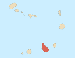 | |
| Mountains | ||
| Streams |
| |
| Points and promontories |
| |
| Reservoirs |
| |
| Other geographic features | ||
| History | ||