Ramhurst, Georgia
| Ramhurst, Georgia | |
|---|---|
| Unincorporated community | |
 Ramhurst, Georgia | |
| Coordinates: 34°41′53″N 84°43′51″W / 34.69806°N 84.73083°WCoordinates: 34°41′53″N 84°43′51″W / 34.69806°N 84.73083°W | |
| Country | United States |
| State | Georgia |
| County | Murray |
| Elevation | 781 ft (238 m) |
| Time zone | Eastern (EST) (UTC-5) |
| • Summer (DST) | EDT (UTC-4) |
| Area code(s) | 706 & 762 |
| GNIS feature ID | 356486[1] |
Ramhurst is an unincorporated community in Murray County, Georgia, United States. The community is located at the intersection of U.S. Route 411 and U.S. Route 76, 5.2 miles (8.4 km) south-southeast of Chatsworth.
References
Municipalities and communities of Murray County, Georgia, United States | ||
|---|---|---|
| City | 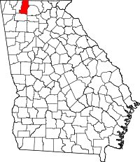 | |
| Town | ||
| Unincorporated communities | ||
This article is issued from Wikipedia - version of the 5/25/2015. The text is available under the Creative Commons Attribution/Share Alike but additional terms may apply for the media files.