Radstadt Tauern
| Radstadt Tauern | |
|---|---|
| Highest point | |
| Peak | Weißeck |
| Elevation | 2,711 m (8,894 ft) |
| Geography | |
| State | Salzburg, Austria |
| Range coordinates | 47°09′N 13°23′E / 47.15°N 13.38°ECoordinates: 47°09′N 13°23′E / 47.15°N 13.38°E |
| Parent range | Low Tauern |
The Radstadt Tauern[1][2][3][4][5] (German: Radstädter Tauern) are a subrange of the Austrian Central Alps in the Austrian Eastern Alps. Together with the Schladming Tauern, the Rottenmann and Wölz Tauern and the Seckau Tauern the Radstadt Tauern form the major range of mountains known as the Low Tauern. The mountains are found in the east of the Austrian state of Salzburg between the upper reaches of the Enns and Mur.
Geography
Location
The Radstadt Tauern form the westernmost part of the Low Tauern. They are bounded to the southwest by the High Tauern, to the northwest by the Pongau and to the east by the Schladming Tauern. Their name comes from the town of Radstadt in the Enns valley.
Neighbouring ranges
The Radstadt Tauern border on the following other mountain ranges of the Alps:
- Schladming Tauern (to the east)
- Nock Mountains (to the southeast)
- Ankogel Group and Hafner Group (to the west)
- Salzburg Slate Alps (to the north)
Boundary
According to the Alpine Club classification of the Eastern Alps the mountains are bounded by the following line, in a clockwise direction:[6] Wagrainer Bach from its confluence with the Salzach – Wagrainer Höhe – Litzlingbach to its confluence with the Enns – Enns to Radstadt – Northern Taurach valley – Obertauern – Southern Taurach valley – Mauterndorf – Neuseß – Mur – Murtörl – Kreealpenbach – Großarlbach to its confluence with the Salzach – Salzach to its confluence with the Wagrainer Bach.
Communications
The eastern edge of the Radstadt Tauern is crossed by the Radstadt Tauern Pass (1,738 m (AA)) and, since about 1970 by the tunnel of the Tauern Autobahn (A10). In the north and south of the range railways and federal roads (Bundesstraßen) run along the upper Enns and upper Mur valleys.
Peaks
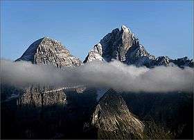
Its highest summits are the Weißeck (2,711 m (AA)), the Hochfeind (2,687 m (AA)) and the Mosermandl (2,680 m (AA)).
Tourism
Alpine huts
- Südwiener Hut, 1,802 m
- Franz Fischer Hut, 2,001 m
- Stickler Hut, 1,752 m
- Speiereck Hut, 2,074 m
- Gnadenalm, 1,290 m
- Tappenkarsee Hut, 1,820 m
- Draugstein Hut, 1,714 m
- Kleinarler Hut, 1,754 m
Ski regions
Skiing in the Radstadt Tauern is concentrated around the village of Obertauern and in the ski areas in the north and northwest, near Altenmarkt-Zauchensee or Flachau. The Radstadt Tauern are also well known for their ski touring terrain.
References
- ↑ Outline of the geology of Austria and selected excursions, Volumes 34-35. Geologische Bundesanstalt (Austria), 1980. p. 60ff. ISBN 978-3-9003-1207-7.
- ↑ Comite national francais de geologie (1980), Geology of the European countries: Austria, Federal Republic of Germany, Ireland, The Netherlands, Switzerland, United Kingdom, Dunod, Univ. of Michigan, 1980, pp. 35ff. ISBN 978-0-8601-0261-8
- ↑ Karl Baedeker (1879). The eastern Alps, including the Bavarian highlands, the Tyrol, Salzkammergut, Styria, and Carinthia, Baedeker, p. 328.
- ↑ Fodor (1992). Fodor's Austria, Fodor, pp. 309/10, D. McKay.
- ↑ The Schladming Tauern at travel.michelin.com. Accessed on 10 Mar 2013.
- ↑ http://www.bergalbum.de/alpeneinteilung_2.htm