Qunaba, Queensland
| Qunaba Queensland | |||||||||||||
|---|---|---|---|---|---|---|---|---|---|---|---|---|---|
 Looking across the Qunaba sugar cane fields towards neighbouring Bargara, 2009 | |||||||||||||
 Qunaba | |||||||||||||
| Coordinates | 24°49′27″S 152°25′49″E / 24.82417°S 152.43028°ECoordinates: 24°49′27″S 152°25′49″E / 24.82417°S 152.43028°E | ||||||||||||
| Population | 822 (2011 census)[1] | ||||||||||||
| Postcode(s) | 4670 | ||||||||||||
| Location | |||||||||||||
| LGA(s) | Bundaberg Region | ||||||||||||
| State electorate(s) | Burnett | ||||||||||||
| Federal Division(s) | Hinkler | ||||||||||||
| |||||||||||||
Qunaba is a locality in the Bundaberg Region, Queensland, Australia.[2] In the 2011 census, Qunaba had a population of 822 people.[1]
Geography
Qunaba is predominantly farming land, much of it used to grow sugarcane. It is mostly flat land with the exception of the Sloping Hummock, commonly known as the Bundaberg Hummock or simply the Hummock (24°50′33″S 152°25′35″E / 24.84250°S 152.42639°E) which provides excellent views over the surrounding flat farmlands.[3][4] The sides of the Hummock have attracted residential development to take advantage of the views.[5]
History
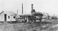

Qunaba takes its name from the Qunaba sugar plantation and mill. Originally established as the Mon Repos plantation and mill, it was taken over in 1900 by the Queensland National Bank who renamed it Qunaba (coined from QUeensland NAtional BAnk).[6]
In 1930, the Bundaberg branch of the Royal Automobile Club of Queensland (RACQ) acquired the land at the top of the Hummock in order to create a park for motoring tourists to enjoy the views.[7] The park was officially opened on 17 October 1931.[8]
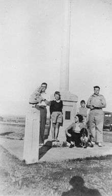
On 14 August 1937, the President of the RACQ unveiled a memorial to the Bundaberg-born aviator Bert Hinkler on the top of the Hummock.[9][10]
Heritage listings
Qunaba has the following heritage listings:
- Sir Anthony's Rest Street: Sir Anthony's Rest, a dry-stone rubble platform, constructed during the visit of the Governor of Queensland, Sir Anthony Musgrave, to Bundaberg in 1888[11]
References
- 1 2 Australian Bureau of Statistics (31 October 2012). "Qunaba". 2011 Census QuickStats. Retrieved 14 November 2015.
- ↑ "Qunaba (entry 44761)". Queensland Place Names. Queensland Government. Retrieved 14 November 2015.
- ↑ "Sir Anthony's Rest (entry 602053)". Queensland Heritage Register. Queensland Heritage Council. Retrieved 1 August 2014.
- ↑ "Sloping Hummock (entry 31177)". Queensland Place Names. Queensland Government. Retrieved 14 November 2015.
- ↑ "Queensland Globe". State of Queensland. Retrieved 14 November 2015.
- ↑ "South Sea Islander Wall (entry 602230)". Queensland Heritage Register. Queensland Heritage Council. Retrieved 1 August 2014.
- ↑ "BUNDABERG R.A.C.Q.". Maryborough Chronicle, Wide Bay and Burnett Advertiser (Qld. : 1860 – 1947). Qld.: National Library of Australia. 6 August 1930. p. 3. Retrieved 14 November 2015.
- ↑ "HUMMOCK LOOKOUT.". Maryborough Chronicle, Wide Bay and Burnett Advertiser (Qld. : 1860 – 1947). Qld.: National Library of Australia. 19 October 1931. p. 5. Retrieved 14 November 2015.
- ↑ "Bert Hinkler | Monument Australia". monumentaustralia.org.au. Retrieved 2015-11-14.
- ↑ "HINKLER MEMORIAL UNVEILED.". Maryborough Chronicle, Wide Bay and Burnett Advertiser (Qld. : 1860 – 1947). Qld.: National Library of Australia. 16 August 1937. p. 6. Retrieved 14 November 2015.
- ↑ "Sir Anthony's Rest (entry 602053)". Queensland Heritage Register. Queensland Heritage Council. Retrieved 1 August 2014.
External links
![]() Media related to Qunaba, Queensland at Wikimedia Commons
Media related to Qunaba, Queensland at Wikimedia Commons