Quinter, Kansas
| Quinter, Kansas | |
|---|---|
| City | |
|
View of Quinter from Interstate 70 | |
 Location within Gove County and Kansas | |
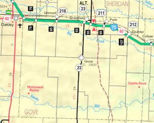 KDOT map of Gove County (legend) | |
| Coordinates: 39°3′57″N 100°14′13″W / 39.06583°N 100.23694°WCoordinates: 39°3′57″N 100°14′13″W / 39.06583°N 100.23694°W | |
| Country | United States |
| State | Kansas |
| County | Gove |
| Area[1] | |
| • Total | 0.99 sq mi (2.56 km2) |
| • Land | 0.99 sq mi (2.56 km2) |
| • Water | 0 sq mi (0 km2) |
| Elevation | 2,664 ft (812 m) |
| Population (2010)[2] | |
| • Total | 918 |
| • Estimate (2015)[3] | 948 |
| • Density | 930/sq mi (360/km2) |
| Time zone | Central (CST) (UTC-6) |
| • Summer (DST) | CDT (UTC-5) |
| ZIP code | 67752 |
| Area code(s) | 785 |
| FIPS code | 20-58250 [4] |
| GNIS feature ID | 0471350 [5] |

Quinter is a city in Gove County, Kansas, United States. As of the 2010 census, the city population was 918.[6]
History
The city of Quinter is built at the location of an old railroad switching site called Melota. A town named Familton was built there in 1885, consisting originally of a hotel.[7] The U.S. Government would not establish a post office under the Familton name, because of possible confusion with other names in the state, so another had to be chosen. The name Quinter was settled upon, after Rev. James Quinter, a local Baptist Brethren minister.[8]
The city received some slight national publicity in November 2006 when longtime resident Waldo McBurney, age 104, was proclaimed the oldest worker in the United States.[9]
Geography
Quinter is located at 39°3′57″N 100°14′13″W / 39.06583°N 100.23694°W (39.065706, -100.236828).[10] According to the United States Census Bureau, the city has a total area of 0.99 square miles (2.56 km2), all of it land.[1]
Demographics
| Historical population | |||
|---|---|---|---|
| Census | Pop. | %± | |
| 1910 | 450 | — | |
| 1920 | 383 | −14.9% | |
| 1930 | 570 | 48.8% | |
| 1940 | 481 | −15.6% | |
| 1950 | 741 | 54.1% | |
| 1960 | 776 | 4.7% | |
| 1970 | 930 | 19.8% | |
| 1980 | 951 | 2.3% | |
| 1990 | 945 | −0.6% | |
| 2000 | 961 | 1.7% | |
| 2010 | 918 | −4.5% | |
| Est. 2015 | 948 | [3] | 3.3% |
| U.S. Decennial Census | |||
2010 census
As of the census[2] of 2010, there were 918 people, 374 households, and 251 families residing in the city. The population density was 927.3 inhabitants per square mile (358.0/km2). There were 425 housing units at an average density of 429.3 per square mile (165.8/km2). The racial makeup of the city was 98.3% White, 0.3% African American, 0.4% Asian, 0.3% from other races, and 0.7% from two or more races. Hispanic or Latino of any race were 2.2% of the population.
There were 374 households of which 29.1% had children under the age of 18 living with them, 58.8% were married couples living together, 6.1% had a female householder with no husband present, 2.1% had a male householder with no wife present, and 32.9% were non-families. 29.9% of all households were made up of individuals and 18.5% had someone living alone who was 65 years of age or older. The average household size was 2.30 and the average family size was 2.87.
The median age in the city was 47.9 years. 23.6% of residents were under the age of 18; 6% were between the ages of 18 and 24; 17.3% were from 25 to 44; 24.5% were from 45 to 64; and 28.6% were 65 years of age or older. The gender makeup of the city was 47.2% male and 52.8% female.
2000 census
As of the census[4] of 2000, there were 961 people, 393 households, and 257 families residing in the city. The population density was 978.0 people per square mile (378.6/km²). There were 463 housing units at an average density of 471.2 per square mile (182.4/km²). The racial makeup of the city was 97.40% White, 0.10% African American, 0.31% Asian, 0.94% from other races, and 1.25% from two or more races. Hispanic or Latino of any race were 1.25% of the population.

There were 393 households out of which 28.2% had children under the age of 18 living with them, 61.1% were married couples living together, 3.3% had a female householder with no husband present, and 34.4% were non-families. 33.8% of all households were made up of individuals and 22.6% had someone living alone who was 65 years of age or older. The average household size was 2.31 and the average family size was 2.97.
In the city the population was spread out with 24.8% under the age of 18, 4.5% from 18 to 24, 19.0% from 25 to 44, 20.2% from 45 to 64, and 31.5% who were 65 years of age or older. The median age was 46 years. For every 100 females there were 81.3 males. For every 100 females age 18 and over, there were 74.6 males.
The median income for a household in the city was $32,098, and the median income for a family was $41,111. Males had a median income of $25,313 versus $17,292 for females. The per capita income for the city was $15,588. About 5.4% of families and 7.6% of the population were below the poverty line, including 9.8% of those under age 18 and 6.4% of those age 65 or over.
Transportation
The concurrent Interstate 70 and U.S. Route 40 pass just south of the city. Old U.S. Route 40 and the current K-212 pass through the city, as does a major Union Pacific railroad line.[11]
Notable people
- Brent Barrett, American actor and tenor
- Scott Huffman, Olympic pole vaulter
- Waldo McBurney, centenarian
- Maggie McIntosh, State legislator
See also
References
- 1 2 "US Gazetteer files 2010". United States Census Bureau. Archived from the original on January 24, 2012. Retrieved 2012-07-06.
- 1 2 "American FactFinder". United States Census Bureau. Retrieved 2012-07-06.
- 1 2 "Annual Estimates of the Resident Population for Incorporated Places: April 1, 2010 to July 1, 2015". Retrieved July 2, 2016.
- 1 2 "American FactFinder". United States Census Bureau. Archived from the original on September 11, 2013. Retrieved 2008-01-31.
- ↑ "US Board on Geographic Names". United States Geological Survey. 2007-10-25. Retrieved 2008-01-31.
- ↑ "2010 City Population and Housing Occupancy Status". U.S. Census Bureau. Archived from the original on July 21, 2011. Retrieved March 6, 2011.
- ↑ Blackmar, Frank Wilson (1912). Kansas: A Cyclopedia of State History, Volume 2. Standard Publishing Company. p. 530.
- ↑ History Of Gove County, Kansas; 1930. Archived December 29, 2011, at the Wayback Machine.
- ↑ http://www.kansas.com/mld/kansas/news/state/15912412.htm[]
- ↑ "US Gazetteer files: 2010, 2000, and 1990". United States Census Bureau. 2011-02-12. Retrieved 2011-04-23.
- ↑ DeLorme. Kansas Atlas & Gazetteer. 4th ed. Yarmouth: DeLorme, 2009, 31. ISBN 0-89933-342-7.
External links
| Wikimedia Commons has media related to Quinter, Kansas. |
- City
- Schools
- USD 293, local school district
- Maps
- Quinter City Map, KDOT
Municipalities and communities of Gove County, Kansas, United States | ||
|---|---|---|
| Cities | 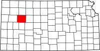 | |
| Townships | ||
| Footnotes | ‡This populated place also has portions in an adjacent county or counties | |