Jerome Township, Gove County, Kansas
| Jerome Township | |
|---|---|
| Township | |
 Location in Gove County | |
| Coordinates: 38°47′09″N 100°29′04″W / 38.78583°N 100.48444°WCoordinates: 38°47′09″N 100°29′04″W / 38.78583°N 100.48444°W | |
| Country | United States |
| State | Kansas |
| County | Gove |
| Area | |
| • Total | 142.96 sq mi (370.28 km2) |
| • Land | 142.96 sq mi (370.25 km2) |
| • Water | 0.01 sq mi (0.02 km2) 0.01% |
| Elevation | 2,585 ft (788 m) |
| Population (2000) | |
| • Total | 132 |
| • Density | 0.9/sq mi (0.4/km2) |
| GNIS feature ID | 0471397 |
Jerome Township is a township in Gove County, Kansas, USA. As of the 2000 census, its population was 132.
Geography
Jerome Township covers an area of 142.96 square miles (370.3 km2) and contains no incorporated settlements.
The streams of Cheyenne Creek and Plum Creek run through this township.
Transportation
Jerome Township contains three airports or landing strips: Beesley Farms Airport, Lundgren Hereford Ranch Airport and Tustin Airport.
References
External links
Municipalities and communities of Gove County, Kansas, United States | ||
|---|---|---|
| Cities | 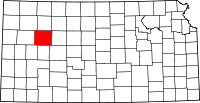 | |
| Townships | ||
| Footnotes | ‡This populated place also has portions in an adjacent county or counties | |
This article is issued from Wikipedia - version of the 11/11/2013. The text is available under the Creative Commons Attribution/Share Alike but additional terms may apply for the media files.