Princeton, Wisconsin
| Princeton, Wisconsin | |
|---|---|
| City | |
|
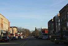
Fulton St., Princeton looking north | |
 Location of Princeton, Wisconsin | |
| Coordinates: 43°51′1″N 89°7′47″W / 43.85028°N 89.12972°WCoordinates: 43°51′1″N 89°7′47″W / 43.85028°N 89.12972°W | |
| Country | United States |
| State | Wisconsin |
| County | Green Lake |
| Area[1] | |
| • Total | 1.64 sq mi (4.25 km2) |
| • Land | 1.54 sq mi (3.99 km2) |
| • Water | 0.10 sq mi (0.26 km2) |
| Elevation[2] | 770 ft (235 m) |
| Population (2010)[3] | |
| • Total | 1,214 |
| • Estimate (2012[4]) | 1,202 |
| • Density | 788.3/sq mi (304.4/km2) |
| Time zone | Central (CST) (UTC-6) |
| • Summer (DST) | CDT (UTC-5) |
| Area code(s) | 920 |
| Website |
cityofprincetonwi |

Princeton is a city in western part of Green Lake County, Wisconsin, United States. The population was 1,214 at the 2010 census. The city is located within the Town of Princeton, though it is politically independent. The Fox River flows through the city, dividing the city into an east half and west half.
History
A post office has been in operation in Princeton since 1849.[5] The city was named after Princeton, Massachusetts.[6]
Geography
According to the United States Census Bureau, the city has a total area of 1.64 square miles (4.25 km2), of which, 1.54 square miles (3.99 km2) is land and 0.10 square miles (0.26 km2) is water.[1]
Demographics
| Historical population | |||
|---|---|---|---|
| Census | Pop. | %± | |
| 1870 | 705 | — | |
| 1880 | 961 | 36.3% | |
| 1890 | 986 | 2.6% | |
| 1900 | 1,202 | 21.9% | |
| 1910 | 1,269 | 5.6% | |
| 1920 | 1,275 | 0.5% | |
| 1930 | 1,183 | −7.2% | |
| 1940 | 1,247 | 5.4% | |
| 1950 | 1,371 | 9.9% | |
| 1960 | 1,509 | 10.1% | |
| 1970 | 1,446 | −4.2% | |
| 1980 | 1,479 | 2.3% | |
| 1990 | 1,458 | −1.4% | |
| 2000 | 1,504 | 3.2% | |
| 2010 | 1,214 | −19.3% | |
| Est. 2015 | 1,185 | [7] | −2.4% |
2010 census
As of the census[3] of 2010, there were 1,214 people, 551 households, and 312 families residing in the city. The population density was 788.3 inhabitants per square mile (304.4/km2). There were 638 housing units at an average density of 414.3 per square mile (160.0/km2). The racial makeup of the city was 97.3% White, 1.0% African American, 0.6% Native American, 0.4% Asian, 0.2% from other races, and 0.6% from two or more races. Hispanic or Latino of any race were 1.5% of the population.
There were 551 households of which 26.0% had children under the age of 18 living with them, 41.9% were married couples living together, 9.8% had a female householder with no husband present, 4.9% had a male householder with no wife present, and 43.4% were non-families. 38.7% of all households were made up of individuals and 20.5% had someone living alone who was 65 years of age or older. The average household size was 2.15 and the average family size was 2.83.
The median age in the city was 44.7 years. 22.9% of residents were under the age of 18; 5% were between the ages of 18 and 24; 22.6% were from 25 to 44; 28.5% were from 45 to 64; and 20.9% were 65 years of age or older. The gender makeup of the city was 46.6% male and 53.4% female.
2000 census
As of the census[9] of 2000, there were 1,504 people, 576 households, and 353 families residing in the city. The population density was 923.5 people per square mile (356.3/km²). There were 636 housing units at an average density of 390.5 per square mile (150.7/km²). The racial makeup of the city was 98.94% White, 0.47% Black or African American, 0.20% Native American, 0.20% Pacific Islander, and 0.20% from two or more races. 0.80% of the population were Hispanic or Latino of any race.
There were 576 households out of which 26.9% had children under the age of 18 living with them, 48.6% were married couples living together, 8.7% had a female householder with no husband present, and 38.7% were non-families. 34.2% of all households were made up of individuals and 21.7% had someone living alone who was 65 years of age or older. The average household size was 2.30 and the average family size was 2.97.
In the city the population was spread out with 21.1% under the age of 18, 6.5% from 18 to 24, 22.5% from 25 to 44, 20.1% from 45 to 64, and 29.7% who were 65 years of age or older. The median age was 45 years. For every 100 females there were 79.0 males. For every 100 females age 18 and over, there were 76.1 males.
The median income for a household in the city was $32,679, and the median income for a family was $41,023. Males had a median income of $31,912 versus $21,719 for females. The per capita income for the city was $18,047. About 5.1% of families and 12.9% of the population were below the poverty line, including 12.0% of those under age 18 and 23.5% of those age 65 or over.
Religion
St. John's Evangelical Lutheran Church, a member of the Wisconsin Evangelical Lutheran Synod, is located on the east side of Princeton.[10] St. John the Baptist Catholic Church is located on the west side of town.[11]
Transportation
Princeton is served by WIS 23 and WIS 73 along Fulton St. and Main St. Wis 23 goes west to Montello and east to Green Lake. Wis 73 goes north to Neshkoro and Wautoma and south to Randolph.
Green Lake County Hwys. D (Fulton St., Main St. & River Rd.), J (Harris St., Main St. & Fulton St.) and T (Farmer St.) also enter into town.
Water St. is the main street in Downtown Princeton.
Airfield
Bed-ah-Wick Field is located just east of downtown Water Street. It is used for small, private planes.
Culture
Princeton has a flea market on Saturdays from mid-April through mid-October.
Notable people
- George R. Currie, Chief Justice of the Wisconsin Supreme Court
- Waldo Flint, Wisconsin State Senator
- William A. Schmidt, Wisconsin State Senator
- Ferdinand T. Yahr, Wisconsin State Senator
Images
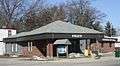 City hall / Police station
 Princeton High School
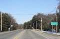 Looking east on WIS 23 at the welcome sign
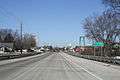 Looking west on WIS 23 and 73 at the welcome sign
References
- 1 2 "US Gazetteer files 2010". United States Census Bureau. Retrieved 2012-11-18.
- ↑ "US Board on Geographic Names". United States Geological Survey. 2007-10-25. Retrieved 2008-01-31.
- 1 2 "American FactFinder". United States Census Bureau. Retrieved 2012-11-18.
- ↑ "Population Estimates". United States Census Bureau. Retrieved 2013-06-24.
- ↑ "Green Lake County". Jim Forte Postal History. Retrieved 26 March 2015.
- ↑ Chicago and North Western Railway Company (1908). A History of the Origin of the Place Names Connected with the Chicago & North Western and Chicago, St. Paul, Minneapolis & Omaha Railways. p. 116.
- ↑ "Annual Estimates of the Resident Population for Incorporated Places: April 1, 2010 to July 1, 2015". Retrieved July 2, 2016.
- ↑ "Census of Population and Housing". Census.gov. Retrieved June 4, 2015.
- ↑ "American FactFinder". United States Census Bureau. Retrieved 2008-01-31.
- ↑ "St. John's Lutheran Church and Sunday School".
- ↑ http://www.stjohnprince.org/. Missing or empty
|title=(help)
External links
- City of Princeton
- Princeton, Wisconsin Chamber of Commerce
- Sanborn fire insurance maps: 1892 1898 1904 1914
| Wikimedia Commons has media related to Princeton, Wisconsin. |
Municipalities and communities of Green Lake County, Wisconsin, United States | ||
|---|---|---|
| Cities | 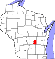 | |
| Villages | ||
| Towns | ||
| CDP | ||
| Unincorporated communities | ||
| Footnotes | ‡This populated place also has portions in an adjacent county or counties | |