Postal, Missouri
| Postal, Missouri | |
|---|---|
| Unincorporated community | |
 Postal, Missouri | |
| Coordinates: 38°53′51″N 93°5′0″W / 38.89750°N 93.08333°WCoordinates: 38°53′51″N 93°5′0″W / 38.89750°N 93.08333°W | |
| Country | United States |
| State | Missouri |
| County | Pettis |
| Elevation | 823 ft (251 m) |
| Time zone | Central (CST) (UTC-6) |
| • Summer (DST) | CDT (UTC-5) |
| Area code(s) | 660 |
| GNIS feature ID | 741170[1] |
Postal is an unincorporated community in Pettis County, Missouri, United States. It is located at 38°53′51″N 93°5′0″W / 38.89750°N 93.08333°W (38.8975195, -93.0832552), and its altitude is 823 feet (251 m).[2]
The community was named for its country post office.[3] A post office called Postal was established in 1891, and remained in operation until 1904.[4] Besides the post office, Postal contained a schoolhouse, which is now defunct.[5]
References
- ↑ "US Board on Geographic Names". United States Geological Survey. 2007-10-25. Retrieved 2008-01-31.
- ↑ U.S. Geological Survey Geographic Names Information System: Postal, Missouri
- ↑ "Pettis County Place Names, 1928–1945". The State Historical Society of Missouri. Archived from the original on June 24, 2016. Retrieved November 27, 2016.
- ↑ "Post Offices". Jim Forte Postal History. Retrieved 27 November 2016.
- ↑ U.S. Geological Survey Geographic Names Information System: Postal School
Municipalities and communities of Pettis County, Missouri, United States | ||
|---|---|---|
| Cities | 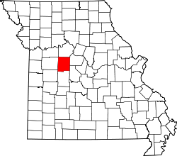 | |
| Villages | ||
| Townships |
| |
| Unincorporated communities | ||
| Ghost towns | ||
| Footnotes | ‡This populated place also has portions in an adjacent county or counties | |
This article is issued from Wikipedia - version of the 12/5/2016. The text is available under the Creative Commons Attribution/Share Alike but additional terms may apply for the media files.