National Environmental Park "Podilski Tovtry"
| Podilian Tovtry (Подільські Товтри) | |
| Medobory | |
| National nature park | |
 View of the entrance to the park, near the historic town of Bakota. | |
| Name origin: Tovtry, specific term for local hills | |
| Country | |
|---|---|
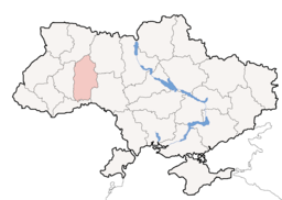
| Region | southern portion of Khmelnytskyi Oblast |
| Districts | Chemerivtsi Raion, Horodok Raion, Kamianets-Podilskyi Raion |
| City | Kamianets-Podilsky |
| Lake | Bakota Bay |
| Rivers | Smotrych River, Zbruch River, Dniester, Ushytsia River |
| Highest point | |
| - elevation | 486 m (1,594 ft) |
| Area | 2,613.16 km2 (1,009 sq mi) |
| Founded | July 27, 1996 |
| Management | Ministry of Natural Environment Protection of Ukraine |
| - location | Kiev |
| IUCN category | II - National Park |
 Location of Khmelnytskyi Oblast in Ukraine
| |
| Website: http://www.tovtry.com/ | |
National Nature Park "Podilski Tovtry" (Ukrainian: Націона́льний приро́дний парк «Поді́льські То́втри») is a national park, located in the Horodok, Kamianets-Podilskyi, and the Chemerivtsi Raions (districts) of Khmelnytskyi Oblast (province) in southern region of the western Ukraine. It is the biggest nature conservation area in Ukraine.
The National Environmental Park "Podilski Tovtry" was created on the decree #476/96 of the President of Ukraine, then Leonid Kuchma, on July 27, 1996, in order to maintain and protect the natural landscape of the Podillia region. The park is a nature-conservational, recreational, culturally enlightening, and scientifically researching institution of national importance. According to the Law of Ukraine of September 21, 2000 #1989-III, the National nature park "Podilski Tovtry" belongs to the National Ecological Network of Ukraine of the Podillya region (Podillya).
General overview

The park's area covers 2,613.16 km² (645,725.9 acre). There are 1,700 different types of flora, 60 of which are included in the Red Book of Ukraine. Also there are 217 different types of fauna, 29 of which are included in the Red Book of Ukraine as well. In total there are 127 objects of nature conservation which contain about 3,000 different types, forms, and sorts of plants.
The park is divided into several functional zones: sacred zone, regulated recreation zone, stationary recreation zone, and managed zone. In those zones are located 21 stationary recreation institutions (such as sanatoriums, profilactoriums, tourist resorts, holiday homes, etc.), some 160 industrial companies, collective and individual farming that cause harm to nature. Therefore, the main goal of the National nature park is the preservation of natural diversity, creation of the organized zones of recreation and wellness.
The parks natural borders serve Zbruch River to the west (south from the Sataniv town), Dniester to the south towards the mouth of Ushytsia River, administrative borders of the Novo Ushytsia and Dunaivtsi Raions to the east, the Dymytrov, Ordzhonikidze, Vatutin collective farms (Horodok Raion) to the north.
The park includes some 14% of state forest fund, over 13% of collective farm forests, and other territories of region. The total forest fund of the park accounts for some 3,015 hectares (7,450 acres).
Major landmarks
- Bakota Bay (Ramsar sites in Ukraine)
- Lower Smotrych River (Ramsar sites in Ukraine)
- 15 various state reserves
- 4 state monuments of nature
- Botanical garden
- 19 archaeological sights
- 302 monuments of historical and cultural heritage (including the Kamianets-Podilskyi Castle), 205 of which are located in the city of Kamianets-Podilsky
See also
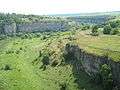
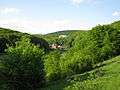
Gallery


_20.JPG)
_14.JPG)
_6.JPG)
External links
Coordinates: 48°41′N 26°35′E / 48.683°N 26.583°E