Pleasant Ridge, Alabama
| Pleasant Ridge, Alabama | |
|---|---|
| Unincorporated community | |
 Pleasant Ridge  Pleasant Ridge | |
| Coordinates: 33°00′51″N 88°05′01″W / 33.01417°N 88.08361°WCoordinates: 33°00′51″N 88°05′01″W / 33.01417°N 88.08361°W | |
| Country | United States |
| State | Alabama |
| County | Greene |
| Elevation | 305 ft (93 m) |
| Time zone | Central (CST) (UTC-6) |
| • Summer (DST) | CDT (UTC-5) |
| Area code(s) | 205 |
| GNIS feature ID | 155209[1] |
Pleasant Ridge, also known as Ridge, is an unincorporated community in Greene County, Alabama, United States. Pleasant Ridge is located on Alabama State Route 14, 17.2 miles (27.7 km) northwest of Eutaw.
History
A post office operated under the name Pleasant Ridge from 1825 to 1918.[2] On April 6, 1865, there was a skirmish between Union forces under the command of Col. John T. Croxton and Confederate forces under the command of Brigadier-General William Wirt Adams near Pleasant Ridge. Croxton was leaving Tuscaloosa, having burned the University of Alabama on April 4.[3] The 6th Kentucky Cavalry Regiment and the 2nd Michigan Volunteer Cavalry Regiment engaged with Adams' forces.[4]
References
- ↑ "Pleasant Ridge". Geographic Names Information System. United States Geological Survey.
- ↑ "Tuscaloosa County". Jim Forte Postal History. Retrieved 30 November 2015.
- ↑ Willis Brewer (1872). Alabama, Her History, Resources, War Record, and Public Men: From 1540 to 1872. Barrett & Brown. p. 260.
- ↑ Benson John Lossing (1874). The Pictorial Field Book of the Civil War in the United States of America. T. Belknap. p. 2.
Municipalities and communities of Greene County, Alabama, United States | ||
|---|---|---|
| Cities | 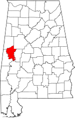 | |
| Towns | ||
| Unincorporated communities | ||
This article is issued from Wikipedia - version of the 10/28/2016. The text is available under the Creative Commons Attribution/Share Alike but additional terms may apply for the media files.