Pimpalgaon Raja
| Pimpalgaon Raja | |
|---|---|
| Village | |
 Pimpalgaon Raja Location in Maharashtra, India | |
| Coordinates: 20°43′00″N 76°26′00″E / 20.71667°N 76.43333°ECoordinates: 20°43′00″N 76°26′00″E / 20.71667°N 76.43333°E | |
| Country |
|
| State | Maharashtra |
| District | Buldana |
| Languages | |
| • Official | Marathi |
| Time zone | IST (UTC+5:30) |
| Vehicle registration | MH-28 |
Pimpalgaon Raja is gram panchayat located in tahsil Khamgaon of Buldhana district of Maharashtra situated on bank of River Dnyanganga. It is 14 km from Khamgaon. Agriculture is main occupation here.
Geography
20° 43' 0" North, 76° 26' 0" south [1]
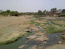
River Dnyanganga by TMK Khan Pimpalgaon Raja
Education
- Jamia Ammar bin Yaseer Rz Pimpalgaon Raja
- Urdu High School &Junior CollegePimpalgaonRaja
- Madarsah Deeniyat Taqiya Masjid
- Other schools are also available for education.
Other
Agriculture is main occupation of people. It is the main source of income for villagers. Dnyanganga river is the source of water for agricultural work. Tandulwadi dam on Dnyanganga river, which supplies water to Nandura and Khamgaon.
Nearby Places
Places around Pimpalgaon Raja:[2]
- Tarwadi (9 km / 6 mi.Tarwadi is 292° West-northwest of Pimpalgaon Raja WNW)
- Goshing (12 km / 8 mi.Goshing is 262° West of Pimpalgaon Raja W)
- Nandura (13 km / 8 mi.Nandura is 8° North of Pimpalgaon Raja N, Pop. 39,650)
- Khamgaon (14 km / 9 mi.Khamgaon is 104° East Southeast of Pimpalgaon Raja ESE, Pop. 94,604)
References
This article is issued from Wikipedia - version of the 11/2/2016. The text is available under the Creative Commons Attribution/Share Alike but additional terms may apply for the media files.