Pill, Tyrol
| Pill | ||
|---|---|---|
 | ||
| ||
 Pill Location within Austria | ||
Location within Tyrol
| ||
| Coordinates: 47°19′15″N 11°40′57″E / 47.32083°N 11.68250°ECoordinates: 47°19′15″N 11°40′57″E / 47.32083°N 11.68250°E | ||
| Country | Austria | |
| State | Tyrol | |
| District | Schwaz | |
| Government | ||
| • Mayor | Hannes Fender | |
| Area | ||
| • Total | 20.9 km2 (8.1 sq mi) | |
| Elevation | 556 m (1,824 ft) | |
| Population (1 January 2016)[1] | ||
| • Total | 1,170 | |
| • Density | 56/km2 (140/sq mi) | |
| Time zone | CET (UTC+1) | |
| • Summer (DST) | CEST (UTC+2) | |
| Postal code | 6130 | |
| Area code | 05242 | |
| Vehicle registration | SZ | |
| Website | www.pill.tirol.gv.at | |

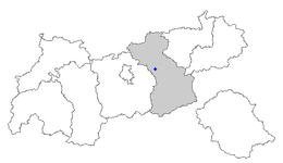
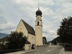
Pill is a municipality in the Schwaz district in the Austrian state of Tyrol.
Geography
Pill lies in the Lower Inn Valley near Schwaz.
References
| Wikimedia Commons has media related to Pill, Tyrol. |
This article is issued from Wikipedia - version of the 1/16/2014. The text is available under the Creative Commons Attribution/Share Alike but additional terms may apply for the media files.