Peso da Régua
| Peso da Régua | |||
|---|---|---|---|
| Municipality | |||
|
The railway station in Peso da Régua | |||
| |||
 | |||
| Coordinates: 41°9′55″N 7°46′35″W / 41.16528°N 7.77639°WCoordinates: 41°9′55″N 7°46′35″W / 41.16528°N 7.77639°W | |||
| Country |
| ||
| Region | Norte | ||
| Subregion | Douro | ||
| Intermunic. comm. | Douro | ||
| District | Vila Real | ||
| Parishes | 8 | ||
| Government | |||
| • President | Nuno Manuel Sousa Pinto de Carvalho Gonçalves (PSD-PPD) | ||
| Area | |||
| • Total | 94.86 km2 (36.63 sq mi) | ||
| Elevation | 255 m (837 ft) | ||
| Population (2011) | |||
| • Total | 17,131 | ||
| • Density | 180/km2 (470/sq mi) | ||
| Time zone | WET/WEST (UTC+0/+1) | ||
| Postal code | 5054 | ||
| Area code | 254 | ||
| Website | http://www.cm-pesoregua.pt | ||


Peso da Régua (Portuguese pronunciation: [ˈpezu ðɐ ˈʁɛɣwɐ]), commonly known as Régua, is a municipality in northern Portugal, in the district of Vila Real. The population in 2011 was 17,131[1] (of which approximately 10,000 are in the town of Régua), in an area of 94.86 km2 (36.63 sq mi) km².[2]
History
| Population of Peso da Régua (1849 - 2004) | ||
|---|---|---|
| Year | Pop. | ±% |
| 1849 | 9,202 | — |
| 1900 | 18,401 | +100.0% |
| 1930 | 20,612 | +12.0% |
| 1960 | 22,634 | +9.8% |
| 1981 | 22,472 | −0.7% |
| 1991 | 21,567 | −4.0% |
| 2001 | 18,832 | −12.7% |
| 2011 | 17,131 | −9.0% |

Peso da Régua was inhabited by Roman and barbarian invasions during the early part of the settled history. Its name, as historians have suggested, developed from a few places: first, the name Vila Reggula a Roman estate that at one time existed near the historic centre; others suggest it originated from the word récua (the ships that plied the waters along the Douro); or derived the word reguengo (a designation for lands that were attributed to the monarchy).[3] Peso da Régua may also have its origin in the word regra (English: rule), alluding to the hereditary rights of descendents achieved through forals.[3] This theory is based on the donated of lands by Counts Henrique and Hugo in 1093, which were transferred to Egas Moniz.[3] It is likely that this rule gave origin to the word Régoa, and later Régua.[3] In relation to the first word, Peso, there are two opinions on its origin: the first, defends the it was derived from the place where the weighing of goods existed, or where taxes were levied; or, secondly, that the word was probably used to define the placed where animals were fed (Portuguese: pensado), or Penso.[3]
Middle Ages
Peso de Régua received its foral from King Sancho I, who conferred on the locality of Godim the municipal charter.[3]
On 3 February 1837, Peso da Régua was elevated to the status of vila (English: town), which included the annexed municipality of Godim, the civil parishes of Godim, Loureiro, Fontelas, Moura Morta and Sedielos.[3]
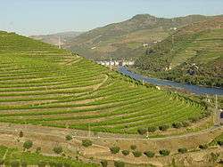
Its important role as municipality only achieved its zenith in 1836, after the Marquess of Pombal designated the Douro, its vineyards and wine, as a quality brand for export.[3] This was helped through the creation of Companhia Geral das Vinhas do Alto Douro, in 1756, which delimited the vineyards of the Douro Valley by granite markers (Portuguese: Marcos de Feitora) to regulate the vineyards and wines produced. After this point, through commercialization and centralization, Régoa began to become the centre of the region.[3]
On 31 December 1859, due to the extinction of the municipality of Canelas, the parishes of Poiares, Covelinhas, Vilarinho de Freires and Galafura were added to the municipality.[3]
Republic
On 11 December 1933, the parish of Vinhos was created from the de-annexed region of Sedielos, resulting in a municipality of eleven parishes threaded along the Douro.[3]
Within the integration of Canelas, in 1976, the municipality grew to twelve.[3]
Peso da Régua was elevated to city on 14 August 1985.[3]
In 1988, the Office Internacional de la Vigne et du Vin recognized the municipality as the Cidade Internacional da Vinha e do Vinho (English: International City of Vine and Wine).[3]
Geography

Administratively, the municipality is divided into 8 civil parishes (freguesias):[4]
- Fontelas
- Galafura e Covelinhas
- Loureiro
- Moura Morta e Vinhós
- Peso da Régua e Godim
- Poiares e Canelas
- Sedielos
- Vilarinho dos Freires
Economy
It cannot be expressed how important Port Wine helped to catapult the fortunes of Peso da Régua:
| “ | The mark founded in the landscape, in the lives of men and the system of relationships, more than its economic importance, to the region and the country, made the Port Wine a cultural fact, a Portuguese cultural patrimony, a universal wine. It is this generous wine, with singular characteristics, old, sweet and aromatic, completed centuries of experience, of work, of knowledge and art, of solidarity and conflicts. Complemented by nature, with united exceptional conditions on the flanks of schist along the Douro valley, the wine of Porto is, like many of the great wines, a human product. Of the Dourense, clearly, but also too the businessmen of Porto, the English, the poor of the Cold Lands of Trás-os-Montes and Beira, the careers of the people of Minho and Galicia...Here, in the demarcated region of wines, that are considered the oldest in the world (1756), in the contemporary sense a denomination of origin, the history of the peoples and vineyards advance, along the centuries and roads parallel.quote text | ” | |
| — Gaspar Martins Pereira, (2000) Memória do Rio. Para uma história da navegação no Douro. Edições Afrontamento. Porto | |||
Tourist boats ply the river from this point carrying tourists through the locks of two dams to Régua. The town is also connected to Porto by train; the Douro railway line runs along the banks of the Douro. Until its closure in 2009, the narrow gauge railway of the Corgo line also served the town.
References
- Notes
- ↑ Instituto Nacional de Estatística
- ↑ Direção-Geral do Território
- 1 2 3 4 5 6 7 8 9 10 11 12 13 14 Câmara Municipal, ed. (2007). "História" (in Portuguese). Peso da Régua: Câmara Municipal de Peso da Régua. Retrieved 17 June 2011.
- ↑ Diário da República. "Law nr. 11-A/2013, pages 552 93-94" (pdf) (in Portuguese). Retrieved 29 July 2014.
- Sources
- Pereira, Gaspar Martins; Barros, Amândio Morais (2000), Memória do Rio. Para uma história da navegação no Douro (in Portuguese), Porto, Portugal: Edições Afrontamento