Perušić
| Perušić | |||
|---|---|---|---|
| Town | |||
|
A sign near Perusic. | |||
| |||
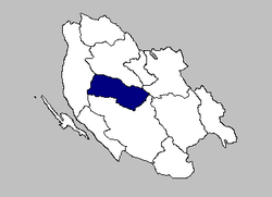 The Municipality of Perušić within Lika-Senj County. | |||
| Country | Croatia | ||
| County | Lika-Senj County | ||
| Municipality | Perušić | ||
| Perušić | 1487 | ||
| Founded by | Dominic and Gaspar Perušić | ||
| Government | |||
| Area | |||
| • Total | 380.69 sq mi (986.0 km2) | ||
| Population (2011) | |||
| • Total | 2,638 | ||
| • Density | 6.9/sq mi (2.7/km2) | ||
| Time zone | UTC+1 Central European Time | ||


Perušić is a town and a municipality in Lika-Senj County, Croatia. The municipality has 2,638 inhabitants, while the town itself has 852.[1] The municipality is part of Lika, a mountainous region in central Croatia. The Kosinj region is located near the town.
Geography
Urban Perušić is located in the southeastern part of Lika, at an altitude of 575-600 m.a.s.l., lying in one of the area's valleys in a field between the railway line east of Citadels (old town Perušić in place today the Tower) and the hills west of Klis, along the main communication (Otocac-Gospić) .
The most important are the routes through which Perušić is well connected: state road D-50 between Otočac and Gospić, the Zagreb-Split highway (highway exit in Peru) and the main railway 11th MP
History
Perušić became an organized settlement in the 16th century, on the border between the Ottoman Empire and Europe. It was first called Perušić in 1487. It was founded by brothers Dominic and Gaspar Perušić, from a noble family who came from the hinterland. The family built a hill fortress. Contemporaneous literature used various names including old city, Gradina, or Perušić tower.
When the Turks conquered the Lika and Krbava Perušić, as part of Lika Sandzak, it became the main stronghold of the Turkish Like. This borderland between three empires (Habsburg Monarchy with the remains of the Croatian-Hungarian Empire, the Venetian Republic and Ottoman Empire) was the scene of constant warfare. Exemption from the Turkish authorities in Lika began in 1685.
Until 1918, Perušić (Perussich before 1850) was part of the Austrian monarchy (Kingdom of Croatia-Slavonia after the compromise of 1867),[2] in the Croatian Military Frontier, administered by the Kommando Ottotschaner Regiment N°II.[3]
In the late 19th century and early 20th century, Perušić was part of the Lika-Krbava County of the Kingdom of Croatia-Slavonia.

During the Croatian War of Independence, Perušić was near the front lines. It was not safe even after the stabilization of the battlefield and the international recognition of Croatia as part of the European Community. In addition to artillery attacks, on 19 January 1992 an infantry attack by Croatian troops was repulsed.[4]
Croatian literacy
According to historical documents Perušić can be called the cradle of Croatian literacy. Shortly after a printing press arrived in the village near Denison, Perušić was mentioned in the Roman Missal according to the law court or Kosinjski Missal (Catholic religious books), one of the oldest printed books in Croatia and Europe, with numerous illustrations and ornaments.
Population
The following settlements comprise the municipality:[1]
- Bakovac Kosinjski—126
- Bukovac Perušićki—91
- Donji Kosinj—494
- Gornji Kosinj—132
- Kaluđerovac—24
- Klenovac—32
- Konjsko Brdo—118
- Kosa Janjačka—98
- Krš—32
- Kvarte—193
- Lipovo Polje—122
- Malo Polje—74
- Mezinovac—24
- Mlakva—51
- Perušić—852
- Prvan Selo—97
- Selo Sveti Marko—34
- Studenci—44
Climate
| Climate data for Perušić | |||||||||||||
|---|---|---|---|---|---|---|---|---|---|---|---|---|---|
| Month | Jan | Feb | Mar | Apr | May | Jun | Jul | Aug | Sep | Oct | Nov | Dec | Year |
| Average high °C (°F) | 11 (52) |
11 (52) |
15 (59) |
18 (64) |
24 (75) |
28 (82) |
31 (88) |
31 (88) |
25 (77) |
21 (70) |
15 (59) |
11 (52) |
20.1 (68.2) |
| Daily mean °C (°F) | 6.5 (43.7) |
6 (43) |
9.5 (49.1) |
13 (55) |
18 (64) |
22 (72) |
24.5 (76.1) |
24.5 (76.1) |
19 (66) |
15.5 (59.9) |
10.5 (50.9) |
7 (45) |
15.5 (59.9) |
| Average low °C (°F) | 2 (36) |
1 (34) |
4 (39) |
8 (46) |
12 (54) |
16 (61) |
18 (64) |
18 (64) |
13 (55) |
10 (50) |
6 (43) |
3 (37) |
9.3 (48.7) |
| Average precipitation mm (inches) | 50 (1.97) |
43 (1.69) |
58 (2.28) |
61 (2.4) |
49 (1.93) |
31 (1.22) |
23 (0.91) |
42 (1.65) |
76 (2.99) |
91 (3.58) |
92 (3.62) |
92 (3.62) |
708 (27.87) |
| Average rainy days | 11 | 8 | 9 | 11 | 8 | 7 | 5 | 6 | 9 | 10 | 13 | 13 | 110 |
| Source: World Weather Online[5] | |||||||||||||
Economy
Farming and agricultural industries are the main occupation. The nearby highway brought up rapid economic development.
Landmarks
Grabovača
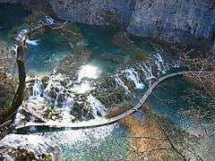
Grabovača is situated between the Lika karstic plains and fields, 2 km from the center of Perušić. It is located at 770 m above sea level near the karst basin of the river Lika. To the west and south is the wide panorama of the karst plateau with the Lika River canyon, an artificial lake and green wall on the far horizon of Velebit. To the east is a tower from the late 17th century parish church and a Cross from the late 17th the century. Nearby is a wealth of underground karst forms, which represent 1/4 of the protected caves in Croatia. The complex variety and abundance of calcite formations are valuable speleological phenomena are located at spatially restricted sites occupying only 1.5 km2.[6]
Kosinj Bridge
Kosinj Bridge is built of stone. It is seventy meters long over the river Lika, connecting Upper and Lower Denison. It was designed in the 19th Century by architect Milivoj Frković, and is built on the model of the early Croatian bridge technique, known as "uklinjenjem stone".
Kruščica
Near Licko field, in 1966 it was created by the accumulation of lake behind an 80 meter high dam, in whose depths is a submerged village with the church of St. Ilya.
Sport
The local soccer team is NK Perušić.
References
- 1 2 "Population by Age and Sex, by Settlements, 2011 Census: Perušić". Census of Population, Households and Dwellings 2011. Zagreb: Croatian Bureau of Statistics. December 2012.
- ↑ Die Poststempel auf der Freimarken-Ausgabe 1867 von Österreich und Ungarn, Edwin Mueller, 1930
- ↑ Map in the Corinphila-Auktionen 2003.
- ↑ "Hrvatski memorijalno-dokumentacijski centar Domovinskog rata". centardomovinskograta.hr. Retrieved 13 July 2015.
- ↑ "Perusic Benkovacki Climate Data". World Weather Online. Retrieved 2012-03-16.
- ↑ "Pećinski park Grabovača - Pećinski park Grabovača pruža priliku posjetiteljima da se vrate u prošlost, tisućama godina unatrag.". pp-grabovaca.hr. Retrieved 13 July 2015.
External links
- Official website (Croatian)
Subdivisions of Lika-Senj County | ||
|---|---|---|
| Towns |  | |
| Municipalities | ||
Coordinates: 44°36′27.28″N 15°14′4.57″E / 44.6075778°N 15.2346028°E