Pennsylvania Route 863
| ||||
|---|---|---|---|---|
 | ||||
| Route information | ||||
| Maintained by PennDOT | ||||
| Length: | 13.988 mi[1] (22.512 km) | |||
| Existed: | 1960s – present | |||
| Major junctions | ||||
| South end: |
| |||
|
| ||||
| North end: |
| |||
| Location | ||||
| Counties: | Lehigh | |||
| Highway system | ||||
| ||||

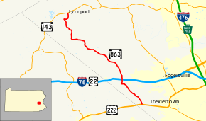
Pennsylvania Route 863 (PA 863) is a state highway in Lehigh County, Pennsylvania. The route runs 13.99 mi (22.51 km) from U.S. Route 222 (US 222) in Upper Macungie Township north to PA 143 in Lynn Township. The route is a two-lane undivided road that runs southeast-northwest through rural areas in western Lehigh County. Along the way, PA 863 has an interchange with Interstate 78 (I-78)/US 22 in Weisenberg Township. The road was originally unpaved, being improved to a bituminous road by the 1940s and a paved road by 1950. PA 863 was designated in the 1960s.
Route description
PA 863 begins at an intersection with US 222 in Upper Macungie Township, Lehigh County, heading north on two-lane undivided Independent Road. The road soon crosses Schantz Road and heads northwest through agricultural areas with some trees and homes, entering Weisenberg Township. The route winds through wooded areas and curves to the west, turning north as it passes more farms. PA 863 crosses Old Route 22 and becomes Golden Key Road, passing businesses as it intersects I-78/US 22 at a diamond interchange. The road continues through commercial areas and passes to the east of a few warehouses. The route passes through the community of Hynemansville and runs northwest through a mix of farms, woods, and residences. PA 863 heads through Seiberlingville and continues northwest through agricultural areas with some woods and homes. The route heads west into Lynn Township and passes through the community of Stines Corner before it winds north through wooded areas. The road heads west by farms before it turns north and winds through forested areas with some fields. The route turns east onto Allemaengel Road and curves north into farmland. Allemaengel Road splits to the east and PA 863 continues north along Behler Road to the residential community of Lynnport, where it ends at PA 143.[2][3]
History
When Pennsylvania first legislated routes in 1911, present-day PA 863 was not legislated as part of a route.[4] The present route of PA 863 existed as an unpaved road by 1915.[5] By 1941, the road was a low-type bituminous road between US 222 and Kistler Valley Road and a high-type bituminous road between Kistler Valley Road and PA 143.[6] By 1950, this roadway was paved.[7] PA 863 was designated in the 1960s to follow its current alignment between US 222 and PA 143.[8] The route has remained on the same alignment since.[3]
Major intersections
The entire route is in Lehigh County.
| Location | mi[1] | km | Destinations | Notes | |
|---|---|---|---|---|---|
| Upper Macungie Township | 0.000 | 0.000 | |||
| Weisenberg Township | 3.444 | 5.543 | Exit 45 (I-78/US 22) | ||
| Lynn Township | 13.988 | 22.512 | |||
| 1.000 mi = 1.609 km; 1.000 km = 0.621 mi | |||||
See also
 U.S. Roads portal
 Pennsylvania portal
- Pennsylvania Route 737, a route that parallels PA 863 to the west
References
- 1 2 Bureau of Maintenance and Operations (January 2015). Roadway Management System Straight Line Diagrams (Report) (2015 ed.). Pennsylvania Department of Transportation. Retrieved June 30, 2015.
- Lehigh County (PDF)
- ↑ Google (January 21, 2015). "Pennsylvania Route 863" (Map). Google Maps. Google. Retrieved January 21, 2015.
- 1 2 Lehigh County, Pennsylvania Highway Map (PDF) (Map). PennDOT. 2014. Retrieved January 5, 2015.
- ↑ Map of Pennsylvania Showing State Highways (PDF) (Map). Pennsylvania Department of Highways. 1911. Retrieved January 1, 2014.
- ↑ Map of the Public Roads in Lehigh County, Pennsylvania (PDF) (Map). Pennsylvania Department of Highways. 1915. Retrieved January 21, 2015.
- ↑ General Highway Map Lehigh County, Pennsylvania (PDF) (Map). Pennsylvania Department of Highways. 1941. Retrieved January 21, 2015.
- ↑ Official Road Map of Pennsylvania (PDF) (Map). Pennsylvania Department of Highways. 1950. Retrieved January 1, 2014.
- ↑ Official Map of Pennsylvania (PDF) (Map). Pennsylvania Department of Highways. 1970. Retrieved December 17, 2014.