Pearson, Georgia
| Pearson, Georgia | |
|---|---|
| City | |
|
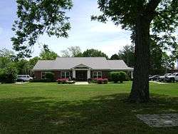
Pearson City Hall and Police Department | |
| Motto: Visit for a day, or stay for a lifetime | |
 Location in Atkinson County and the state of Georgia | |
| Coordinates: 31°17′54″N 82°51′10″W / 31.29833°N 82.85278°WCoordinates: 31°17′54″N 82°51′10″W / 31.29833°N 82.85278°W | |
| Country | United States |
| State | Georgia |
| County | Atkinson |
| Incorporated (city) | Dec. 27, 1890 |
| Area | |
| • Total | 3.4 sq mi (8.7 km2) |
| • Land | 3.4 sq mi (8.7 km2) |
| • Water | 0 sq mi (0 km2) |
| Elevation | 203 ft (62 m) |
| Population (2010) | |
| • Total | 2,117 |
| • Density | 631/sq mi (243.8/km2) |
| Time zone | Eastern (EST) (UTC-5) |
| • Summer (DST) | EDT (UTC-4) |
| ZIP code | 31642 |
| Area code(s) | 912 |
| FIPS code | 13-59808[1] |
| GNIS feature ID | 0332626[2] |
| Website |
www |
Pearson is a city in Atkinson County, Georgia, United States. The population was 2,117 at the 2010 census.[3] The city is the county seat of Atkinson County.[4]
History
Pearson was founded in 1875 as a depot on the Brunswick and Western Railroad. It was incorporated as a town in 1890 and in 1916 as a city.[5] The community was named after Benajah Pearson, a veteran of the Second Seminole War.[6][7]
Geography
Pearson is located at 31°17′54″N 82°51′10″W / 31.29833°N 82.85278°W (31.298368, -82.852827).[8]
According to the United States Census Bureau, the city has a total area of 3.4 square miles (8.7 km2), of which 0.0077 square miles (0.02 km2), or 0.28%, is water.[3]
Demographics
| Historical population | |||
|---|---|---|---|
| Census | Pop. | %± | |
| 1900 | 336 | — | |
| 1910 | 558 | 66.1% | |
| 1920 | 792 | 41.9% | |
| 1930 | 712 | −10.1% | |
| 1940 | 1,057 | 48.5% | |
| 1950 | 1,402 | 32.6% | |
| 1960 | 1,615 | 15.2% | |
| 1970 | 1,700 | 5.3% | |
| 1980 | 1,827 | 7.5% | |
| 1990 | 1,714 | −6.2% | |
| 2000 | 1,805 | 5.3% | |
| 2010 | 2,117 | 17.3% | |
| Est. 2015 | 2,112 | [9] | −0.2% |
As of the census[1] of 2000, there were 1,805 people, 635 households, and 417 families residing in the city. The population density was 624.1 people per square mile (241.1/km²). There were 742 housing units at an average density of 256.6 per square mile (99.1/km²). The racial makeup of the city was 38.73% White, 38.45% African American, 1.05% Native American, 21.61% from other races, and 0.17% from two or more races. Hispanic or Latino of any race were 28.20% of the population.
There were 635 households out of which 38.0% had children under the age of 18 living with them, 37.8% were married couples living together, 21.6% had a female householder with no husband present, and 34.2% were non-families. 28.8% of all households were made up of individuals and 12.0% had someone living alone who was 65 years of age or older. The average household size was 2.81 and the average family size was 3.43.
In the city the population was spread out with 31.5% under the age of 18, 14.4% from 18 to 24, 27.4% from 25 to 44, 17.6% from 45 to 64, and 9.1% who were 65 years of age or older. The median age was 27 years. For every 100 females there were 98.8 males. For every 100 females age 18 and over, there were 96.2 males.
The median income for a household in the city was $22,188, and the median income for a family was $26,830. Males had a median income of $22,313 versus $15,700 for females. The per capita income for the city was $11,311. About 23.7% of families and 30.0% of the population were below the poverty line, including 35.4% of those under age 18 and 31.5% of those age 65 or over.
Education
Atkinson County students in K-12 grades are in the Atkinson County School District, which consists of a two elementary schools (each includes a pre-school program) and a high school.[11] The district has 102 full-time teachers and over 1,648 students.[12]
- Pearson Elementary School
- Willacoochee Elementary School
- Atkinson County Middle School
- Atkinson County High School
Media
References
- 1 2 "American FactFinder". United States Census Bureau. Retrieved 2008-01-31.
- ↑ "US Board on Geographic Names". United States Geological Survey. 2007-10-25. Retrieved 2008-01-31.
- 1 2 "Geographic Identifiers: 2010 Demographic Profile Data (G001): Pearson city, Georgia". U.S. Census Bureau, American Factfinder. Retrieved May 6, 2013.
- ↑ "Find a County". National Association of Counties. Archived from the original on May 31, 2011. Retrieved 2011-06-07.
- ↑ Hellmann, Paul T. (May 13, 2013). Historical Gazetteer of the United States. Routledge. p. 242. Retrieved 30 November 2013.
- ↑ http://georgiainfo.galileo.usg.edu/courthouses/atkinsonCH.htm
- ↑ "Atkinson County, Georgia". Our Georgia History. Retrieved 6 December 2013.
- ↑ "US Gazetteer files: 2010, 2000, and 1990". United States Census Bureau. 2011-02-12. Retrieved 2011-04-23.
- ↑ "Annual Estimates of the Resident Population for Incorporated Places: April 1, 2010 to July 1, 2015". Retrieved July 2, 2016.
- ↑ "Census of Population and Housing". Census.gov. Archived from the original on May 11, 2015. Retrieved June 4, 2015.
- ↑ "Schools in Atkinson County". Georgia Board of Education. Retrieved 9 October 2010.
- ↑ Free District Report, Retrieved May 29, 2010.
External links
- City of Pearson official website
- Salem Church historical marker
Municipalities and communities of Atkinson County, Georgia, United States | ||
|---|---|---|
| Cities | 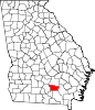 | |
| Unincorporated community | ||