Parc le Breos
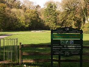
from the entrance of Coed y Parc
Parc le Breos was a great medieval deer park in the south of the Gower Peninsula, about eight miles (13 km) west of Swansea, Wales, and about 1 1⁄4 miles (2.0 km) north of the Bristol Channel. The park was an enclosed, oval area of 6.7 miles (10.8 km) in circumference, covering about 2,000 acres (810 ha) and measuring 2 1⁄2 miles (east–west) by just over 1 3⁄4 miles (4.1 km by 2.9 km). Parc le Breos was established in the 1220s CE by John de Braose (of the powerful Cambro-Norman de Braose dynasty), Marcher Lord of Gower and husband to Margaret Ferch Llywelyn, Llywelyn Fawr's daughter.[1] Other than for deer husbandry, the park received an income from agistment, pannage, and from sales of wild honey, ferns and dead wood. There is evidence of rabbit warrening in the park. Whether the warrens were free or domestic is unknown.[2]
The park's boundary was originally marked by a wooden fence, or pale, on the top of an earth bank inside a ditch. Some parts of the pale survive.[3]
Prehistoric finds and an Iron Age enclosure (above Parkmill) show the area of Parc le Breos to have been settled by modern humans since the earliest times.
History
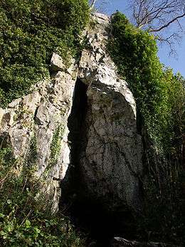
The area that would become Parc le Breos has been inhabited by modern humans since the earliest times. The Cathole Cave – a steep, limestone outcrop, about 50 feet (15 m) from the floor of a dry narrow limestone gorge, now known as the Parc le Breos Cwm valley – has been used as a shelter by bands of Mesolithic hunters and as a Neolithic ossuary.[4] The cave is a deep triangular fissure penetrating the hillside and narrowing towards the top. It has two entrances, with a natural platform outside the larger of the two.[5][6] Excavations revealed two tanged points that may date to c. 28,000 years before present (BP), an interglacial period during the Late Pleistocene.[6] Late glacial tool finds from the Upper Palaeolithic date to c. 12,000 BP. Animal remains were found at the same level as the Upper Palaeolithic tools, providing evidence of the climate c. 12,000 BP: red fox; Arctic fox; brown bear; tundra vole; and possibly reindeer.[7] Animal remains excavated at the cave during the nineteenth century include mammoth, woolly rhinoceros, red deer and giant deer, which are yet to be accurately dated.[8] Several finds date to the Bronze Age: a bronze socketed axe; two human skeletons; and sherds of pottery, from burial urns and other vessels.[6]
Workmen digging for road stone in 1869 uncovered an early Neolithic cromlech built around 5850 BP – now known as Parc Cwm long cairn or Parc le Breos burial chamber (after the park) – about 200 yards (183 m) south of The Cathole Cave, along the Parc le Breos Cwm valley.[9] An excavation later that year revealed human bones (now known to have belonged to at least 40 people), animal remains and Neolithic pottery. Identified in 1937 as one of the Severn-Cotswold type of megalithic chambered tomb, the cromlech was partly restored following an excavation during 1960–1961.[8][10][11] North-West European lifestyles changed around 6,000 BP, from the nomadic lives of the hunter-gatherer, to a settled life of agricultural farming – the Neolithic Revolution. However, analysis of the human remains found at the cromlech show the tomb to have been accessed for up to 800 years and that the people interred within it continued to be either hunter-gatherers or herders, rather than agricultural farmers.[8][12]
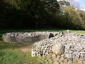
A trapezoidal cairn of rubble – the upper part of the cromlech and its earth covering now removed – about 72 feet (22 m) long by 43 feet (13 m) (at its widest), is revetted by a low dry-stone wall. A bell-shaped, south-facing forecourt, formed by the wall, leads to a central passageway lined with limestone slabs set on end. Human remains had been placed in the two pairs of stone chambers that lead from the passageway. Corpses may have been placed in nearby caves until they decomposed, when the bones were moved to the tomb.[8][12][13]
The Llethryd Tooth Cave, or Tooth Hole cave, is an Early Bronze Age ossuary site in a limestone cave, about 1,500 yards (1.4 km) north, northwest of the Parc Cwm long cairn cromlech, on private land along the Parc le Breos Cwm valley, near the village of Llethryd. The cave was rediscovered by cavers in 1961, who found human bones. The excavation carried out by D.P. Webley & J. Harvey in 1962 revealed the disarticulated remains (i.e. incomplete skeletons) of six adults and two children, dated to the Early Bronze Age or Beaker culture. Other contemporary finds, now held at the Amgueddfa Cymru–National Museum Wales, Cardiff, include collared urn pottery, flaked knives, a scraper, flint flakes, a bone spatula, a needle and bead, and animal bones – the remains of domesticated animals, including cat and dog. Archaeologists Alasdair Whittle and Michael Wysocki note that this period of occupation may be "significant", with respect to Parc Cwm long cairn, as it is "broadly contemporary with the secondary use of the tomb".[11][14][15][16]
The cwmwd of Gŵyr, within the Cantref of Eginog and part of Ystrad Tywi, became part of the Kingdom of Deheubarth – founded by Hywel Dda (c. 920) from the Kingdoms of Dyfed and Seisyllwg.[17] Henry de Beaumont, 1st Earl of Warwick conquered Gŵyr c. 1100, styling himself Lord of Gower.[18][13] Southern Gower was colonised, and eventually became heavily anglicised. Rhys Gryg – fourth son of Rhys ap Gruffydd (The Lord Rhys) – of Deheubarth occupied the peninsula in 1215, but in 1220 he ceded the area to the English, apparently on the orders of Llywelyn ap Iorwerth.[19] Before its emparkment, the area of Parc le Breos had been woodland. Its harvesting was implied on medieval rolls.[20]
The Act of Union (1536) made the Lordship of Gower part of the historic county of Glamorgan, and the south-western section became the Hundred of Swansea.[21]
A Hunting Lodge was built in the 19th century, about 1,200 yards (1,100 m) north east of Parc Cwm long cairn. It is now an hotel and pony trekking (horse riding) centre and retains the name Parc le Breos.[2][22]
Lunnon
The eastern half of Parc le Breos was disemparked, probably in the late 13th century, when it became a demesne farm – a manorial farm also known as a grange. Other than it being woodland in the 1220s, little more is known of the area until this time. The Lord of Gower's grange is noted on an account roll for 1337-8; as 'Grangia de Lunan'. – in which the village of Lunnon would be built.[2][3][23]
During the mid 16th century the remainder of the park changed use too, from a deer park to farmland, when all but the limestone gorge cwm and about 500 acres of woodland was divided into three farms.[2]
Location
The remaining parkland of Parc le Breos is in Coed y Parc, about seven 1⁄2 miles (12 km) west south west of Swansea, Wales, in the southern part of central Gower Peninsula, between the villages of Llanrhidian and Bishopston (Llandeilo Ferwallt). Its nearest village is Parkmill, a small rural settlement about one mile (1.5 km) to the south east.[5][6]
Coed y Parc is owned and managed by Forestry Commission Wales. Pedestrian access is allowed and is free, with free parking for 12–15 cars about 750 feet (230 m) from the site. On the opposite side of the lane to the car park a kissing gate, wide enough for a wheelchair to pass through, leads to an asphalt track running past the cromlech and the length of the gorge, allowing flat, disabled access to within about ten feet (3 m) of the cromlech. Parc Cwm long cairn is maintained by Cadw (to keep), the Welsh Assembly Government's historic environment division.[24][25]
Bibliography
Leighton, David K. 'A fresh look at Parc le Breos', Gower, 50 (1999), pp. 71–79, Publisher: Gower Society, ISSN 0962-0540. [26]
References
- ↑ Davies, John; Jenkins, Nigel; Baines, Menna; Lynch, Peredur, eds. (2008). The Welsh Academy Encyclopaedia of Wales. Cardiff: University of Wales Press. p. 577. ISBN 978-0-7083-1953-6.
- 1 2 3 4 "Parc le Breos, medieval deer parke: Site Details: Coflein". The Royal Commission on the Ancient and Historical Monuments of Wales website. Royal Commission on the Ancient and Historical Monuments of Wales. 15 July 2009. Retrieved 12 September 2009.
- 1 2 "Gower065 Lunnon". Glamorgan-Gwent Archaeological Trust website. Glamorgan-Gwent Archaeological Trust. 2008. Retrieved 2 December 2008.
- ↑ "Cathole Cave, Gower, Stone Age shelter". Casglu'r Tlysau—Gathering the Jewels—The website for Welsh Cultural History. Culturenet Cymru. 2008. Retrieved 4 November 2008.
- 1 2 "Archaeologia Cambrensis: a record of the antiquities of Wales and its Marches and the journal of the Cambrian Archaeological Association". Google Books. London: Cambrian Archaeological Association. 1886. p. 344. Retrieved 24 August 2009.
- 1 2 3 4 "Cat Hole Cave, Parkmill". The Royal Commission on the Ancient and Historical Monuments of Wales website. Royal Commission on the Ancient and Historical Monuments of Wales. 22 October 2007. Retrieved 30 October 2008.
- ↑ Morgan, Prys, ed. (2001). History of Wales, 25,000 BC AD 2000. Stroud, Gloucestershire: Tempus Publishing. p. 22. ISBN 0-7524-1983-8.
- 1 2 3 4 "Parc le Breos burial chamber; Parc Cwm long cairn". The Royal Commission on the Ancient and Historical Monuments of Wales website. Royal Commission on the Ancient and Historical Monuments of Wales. 2006. Retrieved 11 September 2008.
- ↑ Whittle, Alasdair; Wysocki, Michael (1998). "Parc le Breos Cwm Transepted Long Cairn, Gower, West Glamorgan: Date, Contents, and Context". Proceedings of the Prehistoric Society. London: The Prehistoric Society. 64: 140. doi:10.1017/s0079497x00002206. ISSN 0079-497X. Retrieved 7 July 2010.
- ↑ "BBC Wales – History – Themes – The Stone Age". BBC Cymru Wales website. BBC Cymru Wales. 2009. Retrieved 11 September 2009.
- 1 2 "Key Sites Southeast Wales – Neolithic and earlier Bronze Age" (PDF). Research Framework for the Archaeology of Wales website. Research Framework for the Archaeology of Wales. 22 December 2003. Retrieved 4 November 2008.
- 1 2 Morgan (Ed), Prys (2001). History of Wales, 25,000 BC AD 2000. Stroud, Gloucestershire: Tempus. pp. 17–22. ISBN 0-7524-1983-8.
- 1 2 "Gower064 Parc le Breos". Glamorgan-Gwent Archaeological Trust website. Glamorgan-Gwent Archaeological Trust. 2008. Retrieved 11 September 2009.
- ↑ "Tooth Cave-Site Details-Coflein". The Royal Commission on the Ancient and Historical Monuments of Wales website. Royal Commission on the Ancient and Historical Monuments of Wales. 11 July 2002. Retrieved 4 November 2008.
- ↑ Whittle, Alasdair; Wysocki, Michael (1998). "Parc le Breos Cwm Transepted Long Cairn, Gower, West Glamorgan: Date, Contents, and Context". Proceedings of the Prehistoric Society. London: The Prehistoric Society. 64: 177. doi:10.1017/s0079497x00002206. ISSN 0079-497X. Retrieved 25 September 2010.
- ↑ "Bibliography of Cave Sites Literature". Chamberlain, A.T. & Williams, J.P. 2000 A Gazetteer of Welsh Caves, Fissures and Rock Shelters Containing Human Remains. Department of Archaeology and Prehistory, University of Sheffield. 5 December 2000. Retrieved 26 September 2010.
- ↑ Davies, John; Jenkins, Nigel; Baines, Menna; Lynch, Peredur, eds. (2008). The Welsh Academy Encyclopaedia of Wales. Cardiff: University of Wales Press. pp. 207, 246. ISBN 978-0-7083-1953-6.
- ↑ Davies, John; Jenkins, Nigel; Baines, Menna; Lynch, Peredur, eds. (2008). The Welsh Academy Encyclopaedia of Wales. Cardiff: University of Wales Press. p. 332. ISBN 978-0-7083-1953-6.
- ↑ Davies, John; Jenkins, Nigel; Baines, Menna; Lynch, Peredur, eds. (2008). The Welsh Academy Encyclopaedia of Wales. Cardiff: University of Wales Press. p. 757. ISBN 978-0-7083-1953-6.
- ↑ "Parc le Breos, managed woodland: Site Details:Coflein". The Royal Commission on the Ancient and Historical Monuments of Wales website. Royal Commission on the Ancient and Historical Monuments of Wales. 12 September 2009. Retrieved 20 November 2002.
- ↑ Davies, John (1994). A History of Wales. London: Penguin Books. p. 108. ISBN 0-14-014581-8.
- ↑ "Parc-le-Breos". Parc-le-Breos website. Parc-le-Breos. 2008. Retrieved 6 November 2008.
- ↑ "Lunnon, site of medieval manorial farm or grange: Site Details: Coflein". The Royal Commission on the Ancient and Historical Monuments of Wales website. Royal Commission on the Ancient and Historical Monuments of Wales. 1 April 2008. Retrieved 12 September 2008.
- ↑ "About Cadw". Cadw website. Cadw, a division of the Welsh Assembly Government. 2008. Retrieved 11 August 2008.
- ↑ "Places to visit: Parc le Breos Burial Chamber". Cadw website. Cadw, a division of the Welsh Assembly Government. 2008. Retrieved 24 October 2008.
- ↑ Leighton, David (1999). A fresh look at Parc le Breos. Gower Society. pp. 71–79. ISSN 0962-0540.
Coordinates: 51°35′18″N 4°6′45″W / 51.58833°N 4.11250°W