Lordship of Gower
Coordinates: 51°37′12″N 4°08′13″W / 51.620°N 4.137°W
| Lordship of Gower | ||||||||||||
| Arglwyddiaeth Gŵyr | ||||||||||||
| Client state of the Kingdom of England | ||||||||||||
| ||||||||||||
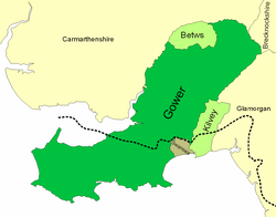 Map of the Lordship, showing the area detached (Betws), the area added (Kilvey Lordship) and the Town and Franchise of Swansea. The language boundary is shown as a dotted line. | ||||||||||||
| Capital | Swansea | |||||||||||
| Government | Lordship | |||||||||||
| Lord | ||||||||||||
| • | 1158 - 1184 | William de Newburgh | ||||||||||
| • | 1331 - 1354 | John, Lord Mowbray | ||||||||||
| • | 1492 | Somerset Lord Herbert | ||||||||||
| Historical era | Middle Ages | |||||||||||
| • | Conquered by the Normans | c. 1116 | ||||||||||
| • | Annexation by Henry VIII | 1536 | ||||||||||
| ||||||||||||
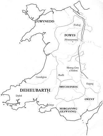
Gower was an ancient marcher lordship of Deheubarth in south-west Wales.
Creation of Lordship
The district, prior to the Norman invasion, was the commote of Gŵyr, a part of Cantref Eginawc. Soon after the Norman conquest of Glamorgan, the southern part of the Gower peninsula was colonised by English speakers, and was formally divided into Welsh Gower and English Gower. In 1203 King John (1199–1216) granted the Lordship of Gower to William III de Braose (d.1211) for the service of one knight's fee.[1] The Charter (Public Record Office, a.R. MisrF,i.L. BooKs, Vol. I.) dated 4 John 23 Feb. (1203) was transcribed by G. T. Clark and published in his Cartae, vol.2, charter no. 283, pp. 287–8 as follows (Grant by King John of the whole land of Gower, with its boundaries, to William de Braose):[2]
Johannes Dei gracia Rex Anglie Dominus Hibernie, Dux Normannie, Aquitannie et Comes Andegavie: Archiepiscopis, episcopis, abbatibus, comitibus, baronibus, justiciaribus, vicecomitibus, ballivis et omnibus ministris et fidelibus suis, salutem. Sciatis nos dedisse concessisse et presenti carta nostra confirmasse dilecto et fideli nostro Willelmo de Braosa totam terram de Guher cum omnibus pertinenciis suis in Wallia. Habendam et tenendam sibi et heredibus suis de nobis et heredibus nostris per servicium unius militis pro omne servicio. jure volumus et firmiter precipimus quod predictus Willelmus de Braoso et heredes sui post ipsum habeant et teneant totam predictam terram de Guher cum omnibus pertinenciis suis in Wallia de nobis et heredibus nostris per predictum servicium sicut predictum est bene et in pace libere et quiete integre plenarie et honorifice cum omnibus libertatibus et liberis consuetudinibus suis in omnibus locis et omnibus rebus ad predictam terram pertinentibus. Hiis testibus: Baldewino comite Albemarlie; Willelmo de Humet, constabulario Normannie; Radulpho Tacone, tunc senescallo Normannie; Roberto de Harecurt; Hugone de Gornaco; Johanne de Pratellis; Petro de Stokes. Datum per manum Hugonis de Well' apud Rothomagum . xxiii die Februarii anno regni nostri quarto.
Added below is the following writing in Norman-French, with marginal title — Ija chartre de la terre de Goulier. E les bundes . dc ineime la terre. (Charter of the Land of Gower and its boundaries...):
Logherne va desques a Amman e parte la terre de Govhek e la terre de OARNEWALDHAr . Amman parte parentre Gtouher e Iskennyn et le Commod p'uED desques a Lleuenedh. E Lleueneth desques a Claudhoweyn. E Claud- HOVFEVN desques a Tourthe. Tourthe departe entre Gtouher et la terre de
Breckeneu desques a Tawy. Tawy departe entre Gouher e la terre le coimte de Gloucestrie desques a Aber Gleys . [De] Gleys . desques a MEYNHiRYON . De Meynhirion . desques a Crimelyn . De Crimelyn . desques a Pulcanan . De Pulcanan desques a Neth . desques a la Meek . et cetera.
Physical description
The Lordship consisted of the country bounded by the rivers Loughor, Amman, Twrch and Tawe. Its caput and chief castle was Swansea, and it extended westward to the end of the Gower Peninsula and northward to Ystalyfera and Gwaun-Cae-Gurwen.
Subsequent history
It remained with the Braose family until the death of William de Braose, 2nd Baron Braose in 1326, when it passed from the family to the husband of one of his two daughters and co-heiresses, Aline and Joan. The parish of Betws was detached from the lordship in the 13th century.
Absorption by Glamorgan
In the first Act of Union (1535),[3] it was transferred, along with the Lordship of Kilvey (roughly, the parish of Llansamlet on the east bank of the Tawe), to the historic county of Glamorgan, when the north-eastern part became the Hundred of Llangyfelach and the south-western part became the Hundred of Swansea. The district (except for the parish of Bishopston- historically dependent on Llandaff) remained part of the Diocese of St David's, until the Diocese of Swansea and Brecon was formed in 1923.
Abolition
The rights of Marcher lords were abolished by the Act of Union, but considerable powers were exercised de facto in Gower, and the claimed rights and privileges of the then Lord Henry Somerset, 5th Duke of Beaufort, were described in detail in Gabriel Powell's Survey of Gower in 1746.[4]
Modern era
The name of the area has continued in use since 1885 in the name of the parliamentary constituency which consists of all the lordship other than Swansea city, but today the name Gower is often incorrectly applied only to the south-western, peninsular part of the district (see Gower Peninsula).
The medieval division between English and Welsh-speaking areas continues, the peninsula and the coastal part of Swansea city are English-speaking, while Welsh is spoken further north, and Ystalyfera and Gwaun-Cae-Gurwen remain bastions of the Welsh language. The boundary shown on the map is that of D T Williams[5] (1931). It had changed little in several centuries.
Notes
- ↑ Sanders, I.J., Feudal Military Service in England, Oxford, 1956, p.12, note 1
- ↑ G. T. Clark Cartae, vol.2, charter no. 283, pp.287-83
- ↑ Laws in Wales Act 1535
- ↑ G Powell, Survey of Gower, B Morris (Ed), Gower Society, 2000, ISBN 0-902767-27-5
- ↑ Williams, D. Trevor, Linguistic divides in South Wales: a historico-geographical study, in Archaeologia Cambrensis 90, 1935, p 253