Serra de Montsant
| Serra de Montsant | |
|---|---|
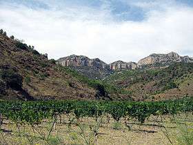 Montsant cliffs towering above the winefields near Cartoixa d'Escaladei, a Carthusian Order monastery. | |
| Highest point | |
| Elevation | 1,163 m (3,816 ft) |
| Coordinates | 41°17′34.63″N 0°47′52.09″E / 41.2929528°N 0.7978028°ECoordinates: 41°17′34.63″N 0°47′52.09″E / 41.2929528°N 0.7978028°E |
| Geography | |
| Location | Priorat, (Catalonia) |
| Parent range | Catalan Pre-Coastal Range |
| Geology | |
| Mountain type | Conglomerate |
Serra de Montsant is a mountain chain in Catalonia, Spain. The main populated area in the range is La Morera de Montsant.
Description
It is part of the Catalan Pre-Coastal Range. The main peaks are Roca Corbatera (1,163 m), Piló dels Senyalets (1,109 m) and la Cogulla (1,063 m).[1] The Serra de Montsant, meaning 'Holy Mountain Range' is thus named because there were many hermits living in the range in early Medieval times.[2]
The Montsant mountain range is currently a protected area, the Serra de Montsant Natural Park.[3]
Local wine
This mountain region is a famous red wine-producing zone; some of the best vineyards are located near the Cartoixa d'Escaladei, a Carthusian Order monastery.[4] It gives its name to the Montsant wine-producing area.
Panorama

Serra de Montsant in winter; south face
See also
References
- ↑ Mapa Topogràfic de Catalunya - Institut Cartogràfic de Catalunya
- ↑ Anuario de estudios medievales; Instituto de Historia Medieval de España 2003; p.982
- ↑ Parc Natural de la Serra de Montsant
- ↑ AADD, Museus i Centres de Patrimoni Cultural a Catalunya. 2010. Departament de Cultura de la Generalitat de Catalunya. Barcelona; p. 87 ISBN 8439354371
External links
| Wikimedia Commons has media related to Montsant. |
This article is issued from Wikipedia - version of the 3/25/2015. The text is available under the Creative Commons Attribution/Share Alike but additional terms may apply for the media files.