Osino, Nevada
| Osino, Nevada | |
|---|---|
| Census-designated place | |
|
View west along Interstate 80 in Osino | |
 Osino | |
| Coordinates: 40°55′56″N 115°39′38″W / 40.93222°N 115.66056°WCoordinates: 40°55′56″N 115°39′38″W / 40.93222°N 115.66056°W | |
| Country | United States |
| State | Nevada |
| County | Elko |
| Area | |
| • Total | 2.48 sq mi (6.42 km2) |
| • Land | 2.48 sq mi (6.42 km2) |
| • Water | 0.0 sq mi (0.0 km2) |
| Elevation | 5,134 ft (1,565 m) |
| Population (2010) | |
| • Total | 709 |
| • Density | 286/sq mi (110.3/km2) |
| Time zone | Pacific (PST) (UTC-8) |
| • Summer (DST) | PDT (UTC-7) |
| Area code(s) | 775 |
| FIPS code | 32-53200 |
| GNIS feature ID | 856101 |
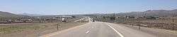
Osino is an unincorporated community and census-designated place (CDP) in Elko County, Nevada.[1] As of the 2010 census it had a population of 709.[2] Osino is located on Interstate 80 9 miles (14 km) northeast of Elko and 41 miles (66 km) southwest of Wells.
References
- ↑ "Osino Census Designated Place". Geographic Names Information System. United States Geological Survey.
- ↑ "Geographic Identifiers: 2010 Demographic Profile Data (G001): Osino CDP, Nevada". U.S. Census Bureau, American Factfinder. Retrieved February 16, 2016.
Municipalities and communities of Elko County, Nevada, United States | ||
|---|---|---|
| Cities | 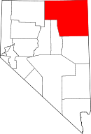 | |
| CDPs | ||
| Other unincorporated communities | ||
| Indian reservation | ||
| Ghost towns | ||
This article is issued from Wikipedia - version of the 2/16/2016. The text is available under the Creative Commons Attribution/Share Alike but additional terms may apply for the media files.