Ojima Domain
Ojima Domain (小島藩 Ojima-han), also known as Kojima Domain,[1] was a Japanese domain of the Edo period. It was located in Suruga Province in modern-day what is now part of the ward of Shimizu in the city of Shizuoka, Shizuoka Prefecture.[2]
History
In May 1689, Matsudaira Nobunari, the adopted son of the castellan of Sunpu Castle, and a wakadoshiyori in the Tokugawa Shogunate was elevated from his former hatamoto status of 4000 koku, to daimyō status of 10,000 koku, and assigned the territory of Ojima, to the east of Sunpu, to be his domain. He was also authorized to start his own branch of the Matsudaira clan, the Takiwaki Matsudaira clan (滝脇松平家). However, due to the small size of his domain, he was not authorized to build a castle, but ruled from a fortified residence, or jin'ya located on the west bank of the Okitsu River.
During the period of the 4th daimyō, Matsudaira Masanobu, the domain faced bankruptcy, which he attempted to resolve with such a large increase in taxes that its peasants rose in a revolt in 1768. Fiscal problems continued over the years, with the 8th daimyō, Matsudaira Nobumoto publishing a tract attempting the explain to both his retainers and his peasants on the need for high taxes and fiscal restraint. The 9th daimyō, Matsudaira Nobuyuki, made all industry within the domain a government monopoly, and sold off permits to raise money.
During the Bakumatsu period, the 11th (and final) daimyō, Matsudaira Nobutoshi, sided with the new Meiji government in the Boshin War of 1867. The domain was abolished with the creation of Shizuoka Domain for the retired ex-Shōgun Tokugawa Yoshinobu, and Nobutoshi was transferred to the newly formed Sakurai Domain in Kazusa province in July 1869.
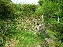
The site of the former Ojima Jinya is now a local history museum, and the remnants of some foundation walls received government protection as a National Historic Site in 2006.[3]
Holdings at the end of the Edo period
As with most domains in the han system, Ojima Domain consisted of several discontinuous territories calculated to provide the assigned kokudaka, based on periodic cadastral surveys and projected agricultural yields.[4][5] All of the domain's territory was within Suruga Province.
- 13 villages in Ihara District
- 12 villages in Abe District
- 6 villages in Udo District
List of daimyo
-
 Matsudaira (Takiwaki) clan, 1704-1868 (fudai; 10,000 koku)[1]
# Name Tenure Courtesy title Court Rank 1 Matsudaira Nobunari (松平信孝) 1689–1690 Tajima-no-kami (但馬守) Lower 5th (従五位下) 2 Matsudaira Nobuharu (松平信孝) 1690–1724 Shimotsuke-no-kami (下野守) Lower 5th (従五位下) 3 Matsudaira Nobutaka (松平信嵩) 1724–1731 Awa-no-kami (安房守) Lower 5th (従五位下) 4 Matsudaira Masanobu (松平昌信) 1731–1771 Awa-no-kami (安房守) Lower 5th (従五位下) 5 Matsudaira Nobunori (松平信義) 1771–1800 Tamba-no-kami (丹波守) Lower 5th (従五位下) 6 Matsudaira Nobukadou (松平信圭) 1800–1815 Awa-no-kami (安房守) Lower 5th (従五位下) 7 Matsudaira Nobutomo (松平信友) 1815–1836 Tango-no-kami (丹後守) Lower 5th (従五位下) 8 Matsudaira Nobumasu (松平信賢) 1836–1851 Tango-no-kami (丹後守) Lower 5th (従五位下) 9 Matsudaira Nobuyuki (松平信進) 1851–1863 Tango-no-kami (丹後守) Lower 5th (従五位下) 10 Matsudaira Nobufumi (松平信書) 1863–1864 Tango-no-kami (丹後守) Lower 5th (従五位下) 11 Matsudaira Nobutoshi (松平信敏) 1864–1868 Tango-no-kami (丹後守) Lower 5th (従五位下)
See also
References
- 1 2 Papinot, Jacques Edmond Joseph. (1906). Dictionnaire d’histoire et de géographie du Japon; Papinot, (2003). "Matsudaira (Takiwaki)" at Nobiliare du Japon, p. 31; retrieved 2013-7-11.
- ↑ "Suruga Province" at JapaneseCastleExplorer.com; retrieved 2013-4-10.
- ↑ Japanese Agency for Cultural Affairs (Japanese)
- ↑ Mass, Jeffrey P. and William B. Hauser. (1987). The Bakufu in Japanese History, p. 150.
- ↑ Elison, George and Bardwell L. Smith (1987). Warlords, Artists, & Commoners: Japan in the Sixteenth Century, p. 18.
External links
- "Ojima" at Edo 300 (Japanese)
Coordinates: 35°05′06″N 138°30′57″E / 35.08500°N 138.51583°E