Nursery, Texas
| Nursery, Texas | |
|---|---|
| unincorporated community | |
 Nursery, Texas  Nursery, Texas Location within the state of Texas | |
| Coordinates: 28°55′25″N 97°05′55″W / 28.92361°N 97.09861°WCoordinates: 28°55′25″N 97°05′55″W / 28.92361°N 97.09861°W | |
| Country | United States |
| State | Texas |
| County | Victoria |
| Elevation | 131 ft (40 m) |
| Time zone | Central (CST) (UTC-6) |
| • Summer (DST) | CDT (UTC-5) |
| Area code(s) | 361 |
| FIPS code | 48-52752[1] |
| GNIS feature ID | 1364246[2] |
Nursery is an unincorporated community in Victoria County, Texas, United States. It is part of the Victoria Metropolitan Statistical Area.
On April 12, 1833, Silvestre De León and his wife Rosalie received a 4,428-acre tract of land from the Mexican government. Nursery was founded in 1884 on part of that land.[3][4]
The Nursery Independent School District serves area elementary school students in grades kindergarten through five, while sixth- through 12th-graders attend the nearby districts of Cuero and Victoria.
References
- ↑ "American FactFinder". United States Census Bureau. Retrieved 2008-01-31.
- ↑ "US Board on Geographic Names". United States Geological Survey. 2007-10-25. Retrieved 2008-01-31.
- ↑ "Nursery, Texas". Texas Escapes. Texas Escapes - Blueprints For Travel, LLC. Retrieved 19 March 2011.
- ↑ Roell, Craig H. "TSHA-Nursery, Texas". Handbook of Texas Online. Texas State Historical Association. Retrieved 19 March 2011.
External links
Municipalities and communities of Victoria County, Texas, United States | ||
|---|---|---|
| City | 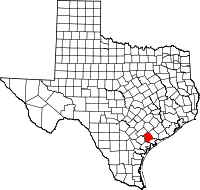 | |
| CDPs |
| |
| Other unincorporated communities | ||
This article is issued from Wikipedia - version of the 7/30/2016. The text is available under the Creative Commons Attribution/Share Alike but additional terms may apply for the media files.