Nukutavake Airport
| Nukutavake Airport Aérodrome de Nukutavake | |||||||||||
|---|---|---|---|---|---|---|---|---|---|---|---|
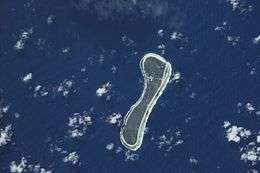 NASA satellite image of Nukutavake | |||||||||||
| IATA: NUK – ICAO: NTGW | |||||||||||
| Summary | |||||||||||
| Airport type | Public | ||||||||||
| Operator | DSEAC Polynésie Française | ||||||||||
| Serves | Nukutavake | ||||||||||
| Location | Nukutavake, Tuamotu, French Polynesia | ||||||||||
| Elevation AMSL | 17 ft / 5 m | ||||||||||
| Coordinates | 19°17′06″S 138°46′19″W / 19.28500°S 138.77194°WCoordinates: 19°17′06″S 138°46′19″W / 19.28500°S 138.77194°W | ||||||||||
| Map | |||||||||||
 NUK Location of the airport in French Polynesia | |||||||||||
| Runways | |||||||||||
| |||||||||||
|
Source: French AIP.[1] | |||||||||||
Nukutavake Airport (IATA: NUK, ICAO: NTGW) is an airport serving the village of Tavananui, located on the Nukutavake island, in the Tuamotu group of atolls in French Polynesia, 1,125 kilometres (699 mi) from Tahiti. The closest land is small Pinaki Atoll, located 15 kilometres (9.3 mi) to the southeast. Vairaatea Atoll Atoll lies 38 kilometres (24 mi) to the west of Nukutavake.
The airport was inaugurated in 1981.
Airlines and destinations
Passenger
| Airlines | Destinations |
|---|---|
| Air Tahiti | Hao, Tatakoto |
References
- ↑ NTGW – Nukutavake. AIP from French Service d'information aéronautique, effective 8 December 2016.
External links
Tuamotus Gambiers | Islands/Atolls: | ||
|---|---|---|---|
| Island groups: | |||
This article is issued from Wikipedia - version of the 12/5/2016. The text is available under the Creative Commons Attribution/Share Alike but additional terms may apply for the media files.