Aratika
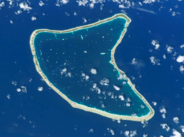 NASA picture of Aratika Atoll | |
 Aratika | |
| Geography | |
|---|---|
| Location | Pacific Ocean |
| Coordinates | 15°32′S 145°32′W / 15.533°S 145.533°WCoordinates: 15°32′S 145°32′W / 15.533°S 145.533°W |
| Archipelago | Tuamotus |
| Area |
145 km2 (56 sq mi) (lagoon) 8.3 km2 (3 sq mi) (above water) |
| Length | 20.8 km (12.92 mi) |
| Width | 10.7 km (6.65 mi) |
| Administration | |
|
France | |
| Overseas collectivity | French Polynesia |
| Administrative subdivision | Tuamotus |
| Commune | Fakarava |
| Largest settlement | Paparara |
| Demographics | |
| Population | 160[1] (2012) |
| Pop. density | 19 /km2 (49 /sq mi) |

Aratika[2] is an atoll in the Tuamotu group in French Polynesia. The nearest land is Kauehi Atoll, located 35 km to the south east.
Aratika has an unusual butterfly shape. Its length is 20.8 km2 (8.0 sq mi) and its maximum width 10.7 km2 (4.1 sq mi) . It has a land area of approximately 8.3 km2 (3.2 sq mi) . The lagoon is wide and deep, and can be entered by two navigable passes.
Aratika had 160 inhabitants in 2012. The main village is called Paparara.
History
Aratika appears in some maps as "Carlshoff Island". This atoll was visited by the Charles Wilkes expedition on September 3, 1839. Prior to the pearl market slump at the turn of the century, Aratika was home to about 2000 people, thereafter dropping to about 200.
Aratika has a private airfield which opened in 1998 and is owned by the Fourcade company. Much of the island's main infrastructure, including the school in 2004 and many business from Paparara village were moved there due to ease of access to and from the airstrip.
The population number has been slowly declining and halves when the children go to school from the age of 11 as there is only a primary school on the island which has one class for 3-11 year olds.
Administration
Aratika Atoll belongs to the commune of Fakarava, which consists of Fakarava, as well as the atolls of Aratika, Kauehi, Niau, Raraka, Taiaro and Toau.
Images & Maps
|
.jpg)
.jpg)
References
- ↑ "Population". Institut de la statistique de la Polynésie française. Retrieved 24 September 2014.
- ↑ Young, J.L. (1899). "Names of the Paumotu Islands, with the old names so far as they are known.". Journal of the Polynesian Society. 8 (4): 264–268. Retrieved 7 January 2015.
External links
- Aratika Atoll FP (EVS Islands)
- Shuttle Image ISS005-E-13941 (Astronaut Photography)
- Aratika Atoll FP (Oceandots.com) at the Wayback Machine (archived December 23, 2010)
- Tuamotu Atolls List (Pacific Image)
Tuamotus Gambiers | Islands/Atolls: | ||
|---|---|---|---|
| Island groups: | |||