Northville, Fulton County, New York
| Northville, Fulton County, New York | |
|---|---|
| Village | |
 Northville  Northville | |
| Coordinates: 43°13.5′N 74°10.5′W / 43.2250°N 74.1750°WCoordinates: 43°13.5′N 74°10.5′W / 43.2250°N 74.1750°W | |
| Country | United States |
| State | New York |
| County | Fulton |
| Town | Northampton |
| Area | |
| • Total | 1.4 sq mi (3.6 km2) |
| • Land | 1.0 sq mi (2.7 km2) |
| • Water | 0.3 sq mi (0.9 km2) |
| Elevation | 807 ft (246 m) |
| Population (2010) | |
| • Total | 1,099 |
| • Density | 1,058/sq mi (408.4/km2) |
| Time zone | Eastern (EST) (UTC-5) |
| • Summer (DST) | EDT (UTC-4) |
| ZIP code | 12134 |
| Area code(s) | 518 |
| FIPS code | 36-53770 |
| GNIS feature ID | 0958987 |
| Website |
www |
Northville is a village in Fulton County, New York. The population was 1,099 at the 2010 census.[1] The village is in the northern part of the town of Northampton and is northeast of Gloversville.
History
The site of the village was first settled around 1786, but areas south of the village were settled around 1762. The village was once on high ground next to the Sacandaga River valley. When the Sacandaga Reservoir was flooded in 1930, that valley became an arm of the lake.
Northville was incorporated in 1873, within the town of Northampton. The Conklingville Dam, finished in 1929, brought about the expansion of the Great Sacandaga Lake to the edge of the village.
The Northville Historic District was added to the National Register of Historic Places in 2014.[2]
Geography
According to the United States Census Bureau, the village has a total area of 1.4 square miles (3.6 km2), of which 1.0 square mile (2.7 km2) is land and 0.35 square miles (0.9 km2), or 24.89%, is water.[1]
The village is located at 43°13.5′N 74°10.5′W in the Adirondack Park on a northern extension of the Great Sacandaga Lake. The Sacandaga River enters the lake to the west the village. The river and lake are part of the Hudson River watershed.
The village is just east of New York State Route 30, connected to the highway by a bridge over the Sacandaga River, and is also served by County Roads 143, 149, and 153. Route 30 leads north 29 miles (47 km) to Speculator in the Adirondacks and south 24 miles (39 km) to Amsterdam on the Mohawk River.
Demographics
| Historical population | |||
|---|---|---|---|
| Census | Pop. | %± | |
| 1880 | 763 | — | |
| 1890 | 792 | 3.8% | |
| 1900 | 1,046 | 32.1% | |
| 1910 | 1,130 | 8.0% | |
| 1920 | 1,190 | 5.3% | |
| 1930 | 1,250 | 5.0% | |
| 1940 | 1,111 | −11.1% | |
| 1950 | 1,114 | 0.3% | |
| 1960 | 1,156 | 3.8% | |
| 1970 | 1,192 | 3.1% | |
| 1980 | 1,304 | 9.4% | |
| 1990 | 1,180 | −9.5% | |
| 2000 | 1,139 | −3.5% | |
| 2010 | 1,099 | −3.5% | |
| Est. 2015 | 1,065 | [3] | −3.1% |
As of the census[5] of 2000, there were 1,139 people, 495 households, and 316 families residing in the village. The population density was 1,070.9 people per square mile (414.9/km2). There were 598 housing units at an average density of 562.2 per square mile (217.8/km2). The racial makeup of the village was 98.07% White, 0.44% African American, 0.70% Asian, 0.53% from other races, and 0.26% from two or more races. Hispanic or Latino of any race were 1.40% of the population.
There were 495 households out of which 27.3% had children under the age of 18 living with them, 47.5% were married couples living together, 11.3% had a female householder with no husband present, and 36.0% were non-families. 31.3% of all households were made up of individuals and 18.4% had someone living alone who was 65 years of age or older. The average household size was 2.30 and the average family size was 2.86.
In the village the population was spread out with 23.5% under the age of 18, 8.2% from 18 to 24, 23.4% from 25 to 44, 25.5% from 45 to 64, and 19.5% who were 65 years of age or older. The median age was 40 years. For every 100 females there were 92.4 males. For every 100 females age 18 and over, there were 86.1 males.
The median income for a household in the village was $37,566, and the median income for a family was $44,792. Males had a median income of $30,391 versus $21,771 for females. The per capita income for the village was $17,808. About 10.1% of families and 13.4% of the population were below the poverty line, including 23.4% of those under age 18 and 8.4% of those age 65 or over.
Education
Northville is home to Northville High School, which is operated by the Northville Central School District.
In popular culture
- Northville was the setting of a 1997 two-part episode of the television series The X-Files. In the two episodes, "Tempus Fugit" and "Max", a passenger plane carrying a former alien abductee, crashed into the ground near the village of Northville. The X-Files team investigates and soon discovers a UFO at the bottom of the Great Sacandaga Lake. The production was not filmed in Northville, although the production crew did contact the village government for specific information regarding police vehicles, maps, etc.
References
- 1 2 "Geographic Identifiers: 2010 Census Summary File 1 (G001), Northville village, New York". American FactFinder. U.S. Census Bureau. Retrieved June 23, 2016.
- ↑ "National Register of Historic Places". Weekly List of Actions Taken on Properties: 5/05/14 through 5/09/14. National Park Service. 2014-05-16.
- ↑ "Annual Estimates of the Resident Population for Incorporated Places: April 1, 2010 to July 1, 2015". Retrieved July 2, 2016.
- ↑ "Census of Population and Housing". Census.gov. Retrieved June 4, 2015.
- ↑ "American FactFinder". United States Census Bureau. Retrieved 2008-01-31.
External links
Municipalities and communities of Fulton County, New York, United States | ||
|---|---|---|
| Cities | 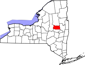 | |
| Towns | ||
| Villages | ||
| CDP | ||
| Other Hamlets | ||
| Footnotes | ‡This populated place also has portions in an adjacent county or counties | |