North Point Station
North Point 北角 | ||||||||||||||||||||||||||||||||||||
|---|---|---|---|---|---|---|---|---|---|---|---|---|---|---|---|---|---|---|---|---|---|---|---|---|---|---|---|---|---|---|---|---|---|---|---|---|
| MTR rapid transit station | ||||||||||||||||||||||||||||||||||||
 Platform 3 | ||||||||||||||||||||||||||||||||||||
| Chinese name | ||||||||||||||||||||||||||||||||||||
| Chinese | 北角 | |||||||||||||||||||||||||||||||||||
| ||||||||||||||||||||||||||||||||||||
| General information | ||||||||||||||||||||||||||||||||||||
| Location |
Near Roca Centre, King's Road, North Point Eastern District, Hong Kong | |||||||||||||||||||||||||||||||||||
| Coordinates | 22°17′27″N 114°12′03″E / 22.2909°N 114.2007°ECoordinates: 22°17′27″N 114°12′03″E / 22.2909°N 114.2007°E | |||||||||||||||||||||||||||||||||||
| Operated by | MTR Corporation | |||||||||||||||||||||||||||||||||||
| Line(s) | ||||||||||||||||||||||||||||||||||||
| Platforms | 4 (island platforms) | |||||||||||||||||||||||||||||||||||
| Connections | Bus, public light bus, tram, ferry | |||||||||||||||||||||||||||||||||||
| Construction | ||||||||||||||||||||||||||||||||||||
| Structure type | Underground | |||||||||||||||||||||||||||||||||||
| Platform levels | 2 | |||||||||||||||||||||||||||||||||||
| Disabled access | Yes | |||||||||||||||||||||||||||||||||||
| Other information | ||||||||||||||||||||||||||||||||||||
| Station code | NOP | |||||||||||||||||||||||||||||||||||
| History | ||||||||||||||||||||||||||||||||||||
| Opened |
| |||||||||||||||||||||||||||||||||||
| Services | ||||||||||||||||||||||||||||||||||||
| ||||||||||||||||||||||||||||||||||||
| Location | ||||||||||||||||||||||||||||||||||||
|
North Point Location within the MTR system | ||||||||||||||||||||||||||||||||||||
North Point (Chinese: 北角) is a station on the Hong Kong MTR Island Line and the western terminus of the Tseung Kwan O Line, located in North Point on Hong Kong Island. The livery of the station is tomato orange.
History
This station was opened in 1985 upon the completion of the Island Line. Until 2001, the station was only used by that line, and the layout of the station at that time featured a stacked side platform arrangement with trains running towards Sheung Wan Station operating on the level above trains running towards Chai Wan Station. Between 2001 and 2002, this station was expanded to facilitate a cross-platform interchange with the Tseung Kwan O Line. A new platform was constructed on each level opposite the existing platform and the station served as the temporary terminus of Kwun Tong Line. On August 4, 2002, the section of Tseung Kwan O Line from this station to Yau Tong was opened to allow passengers to develop familiarity with the new cross-harbour interchange arrangement. Since August 18, 2002, this station serves as the interchange station between the two lines as well as the terminus of Tseung Kwan O Line.
Compared to cross-platform arrangements at other MTR stations, the transfer distance is longer here; however, it is nevertheless much more convenient for commuters to transfer than passing through the corridors in Quarry Bay Station, which provides no cross-platform arrangement.
Station layout
| G | - | Exits |
| Walkway | Walkway | Exits, walkway to all exits |
| Walkway | Walkway | MTRshops Walkway to all exits |
| C | Concourse | Customer Service, MTRshops Vending machines, Automatic teller machines Octopus Promotion Machine |
| Upper Level Platforms |
Platform 2 | ← Island Line towards Kennedy Town (Fortress Hill) |
| Island platform, doors will open on the left for Island Line, right for Tseung Kwan O Line | ||
| Platform 4 | ← Tseung Kwan O Line termination platform | |
| Lower Level Platforms |
Platform 1 | Island Line towards Chai Wan (Quarry Bay) → |
| Island platform, doors will open on the right for Island Line, left for Tseung Kwan O Line | ||
| Platform 3 | Tseung Kwan O Line towards Po Lam (Quarry Bay) → Tseung Kwan O Line towards LOHAS Park peak hours only (Quarry Bay) → | |
Entrances/exits
All exits are located on King's Road and the side streets nearby.[2]
- A1/A4: Java Road
- A2: Marble Road
- A3: Odeon Plaza
- B1/B2/B3: King's Road
- B4: Tsat Tze Mui Road
Transport connections
North Point is the home of a large bus terminus, situated at the North Point Ferry Pier. (Exit A1) At the same time, other modes of transport like buses, trams and taxis are accessed at King's Road, which can be reached through Exits B1 and B3.
Ferry
The North Point Ferry Pier (entrance/exit A1) provides services to Hung Hom, Kowloon City and Kwun Tong. Passengers who wish to take the ferry should leave North Point Station at entrance/exit A1, and follow Shu Kuk Street until they reach the bus terminus. The ferry pier is by the shore.
Gallery
 Long passageway between two platforms
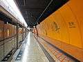 Platform 1 (Towards Chai Wan)
 Platform 2 (Towards Kennedy Town)
 Platform 4 (termination platform)
| Wikimedia Commons has media related to North Point Station. |
See also
References
- ↑ "North Point Station layout" (PDF). MTR Corporation. Retrieved 31 July 2014.
- ↑ "North Point Station street map" (PDF). MTR Corporation. Retrieved 30 June 2014.